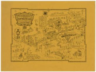
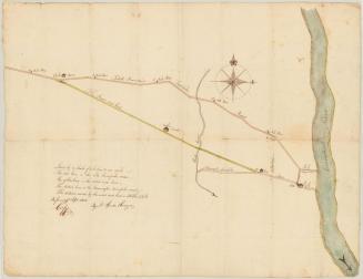
Ye Map of Farmington
DraftsmanDrawn by
Lydia B. Hewes
(American, 1899 - 1986)
Date1926
MediumDrawing; watercolor and ink on wove paper
DimensionsPrimary Dimensions (image height x width): 12 1/8 x 10 1/2in. (30.8 x 26.7cm)
Sheet (height x width): 12 1/8 x 10 1/2in. (30.8 x 26.7cm)
ClassificationsGraphics
Credit LineConnecticut Museum of Culture and History collection
Object number2005.189.0
DescriptionManuscript map of Farmington, Connecticut, depicting the Farmington and Pequabuck Rivers and the Farmington Canal, the town and its public buildings, and the surrounding area. The railroad station and mail coach road are shown on the left, along with the old Indian burying ground and Round Hill. Below the town is a cluster of mountain peaks, including Rattlesnake Mountain and "Hospital Rock," "where smallpox once was isolated." On the right is an area where "ye mastodon grazed and left his bones 1000 years and more ago." Avon College appears at the very top of the map. Most of the drawings have labels identifying them.
Label TextThe L.B. Hewes who drew this map may have been Lydia B. Hewes, the young wife of J. Ellicot Hewes, who was appointed judge of the Farmington Town Court in 1926. This highly personal little map includes allusions to Miss Porter's School (The Main School Building and the Sarah Porter Memorial "famous for church fairs and waffles"), Avon Old Farms School (Avon College) and local landmarks such as "The (Avon) Cider Mill where they make sweet cider" and "Ye Old Grist Mill." One house is identified as "Underground R.R. Station." Other historical references include "Will Warren's Den," "The Aqueduct," "The Elm Tree Inn where Washington spent the night," and the "Old Indian Burying Ground."
NotesCartographic Note: No scaleStatus
Not on view