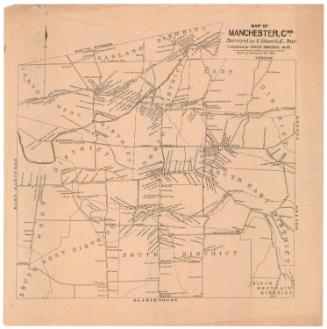
Glastenbury
PublisherPublished by
Baker & Tilden
(founded 1869)
Date1869
MediumLithography; black printer's ink on wove paper
DimensionsPrimary Dimensions (image height x width): 10 7/8 x 15 7/8in. (27.6 x 40.3cm)
Sheet (height x width): 12 7/8 x 17in. (32.7 x 43.2cm)
ClassificationsGraphics
Credit LineGift of the estate of Morgan B. Brainard
Object number1963.96.1
DescriptionMap of the town of Glastonbury, Connecticut, from the town lines of East Hartford and Manchester to the north, Marlborough and the Tolland County line to the east, Middlesex County to the south, and the Connecticut River to the west. It is divided into 18 numbered districts divided by broken solid lines. Roads are shown but are not labeled, and are lined with small black squares representing the locations of residences and businesses, labeled with the owner's name. Natural features depicted include elevation, conveyed through hachure marks, brooks, lakes and ponds.
Label TextThe name of the town of Glastonbury is mispelled on this map. This is especially surprising since the map was included in an atlas of Hartford County published by Baker & Tilden in nearby Hartford, Connecticut in 1869. While the plates in that atlas were all brightly hand-colored, this map is black and white and may represent an early proof state. However, fold lines on the map may indicate that it was separately issued.
NotesCartographic Note: Scale: 1 inch equals 200 rodsStatus
Not on view


Kellogg & Bulkeley
1910-1915
Kellogg & Bulkeley
1915-1920