
Map of Lyme and Vicinity
PrinterPrinted by
Unknown
Datebefore 1942
MediumLithography; blue printer's ink on wove paper
DimensionsPrimary Dimensions (image height x width): 19 1/2 x 16 1/4in. (49.5 x 41.3cm)
Sheet (height x width): 20 1/8 x 17 1/8in. (51.1 x 43.5cm)
ClassificationsGraphics
Credit LineGift of Newton C. Brainard
Object number1954.34.2
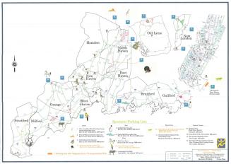
DescriptionMap of Lyme, Old Lyme and part of East Lyme, Connecticut, from the Middlesex County line to the north, East Lyme to the east, the Long Island Sound to the south, and the Connecticut River to the west. Roads are depicted and labeled with their names or route numbers, with small black squares marking the locations of buildings. To the left is a list of corners that correspond with numbers on the map. An unnamed railroad line -- most likely the New York and New Haven Railroad -- is shown at the bottom, running east-west through the town. Elevation is conveyed with contour lines. Selden Neck State Park is shown between the Connecticut River and Selden Creek.
Label TextA later edition of this map was used by the Lyme Minute Men to show civil defense sites in the Lyme area. The Lyme Minute Men, a local sportsman's club, served as a volunteer reserve unit during World War II. It is possible that they used this map prior to the war to help them local local hunting grounds. Stone Ranch, the military reservation in East Lyme used by the Connecticut National Guard, was open to hunters in the 1930s.
NotesCartographic Note: Scale: About 1 5/8 inches equals 1 mileStatus
Not on view


Object/Object