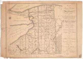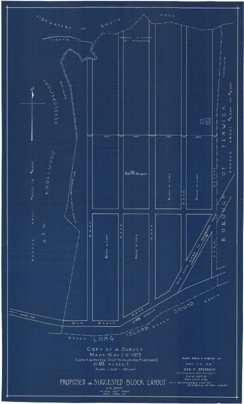
Proposed or Suggested Block Layout, Borough of Fenwick
SurveyorSurveyed by
George C. Stoddard
(American, 1854 - 1922)
Date1912
MediumBlueprint; cyanotype on paper
DimensionsPrimary Dimensions (image height x width): 28 1/8 x 16 3/4in. (71.4 x 42.5cm)
Sheet (height x width): 29 x 17 5/8in. (73.7 x 44.8cm)
ClassificationsGraphics
Credit LineGift of Newton C. Brainard
Object number1954.34.1
DescriptionBlueprint of a proposed block layout east of the new Knollwood development in Fenwick, Old Saybrook, Connecticut, with South Cove to the north, Park Avenue to the east, the Long Island Sound to the south, and an unnamed road to the west. There are five roads running north-south, with one running east-west, and undivided blocks of land in between. The width measurements in feet are provided for the roads and blocks, and the area in acres for one block which presumably applies to the others.
Label TextFenwick developed as a summer colony for wealthy and prominent Hartford citizens and their families, following the completion of the Connecticut Valley Railroad in 1871. The area near Saybrook Point developed quickly, but this 1912 map suggests that there were still lots available in the area west of Park Avenue and east of the new Knollwood development. By this date, private automobiles were already beginning to replace the railroad as the primary means of transportation, but roads remained rough and the fact that a family traveled to Fenwick by "auto" was considered worthy of notice in the society pages of the Hartford Courant.
NotesCartographic Note: Scale: 1 inch equals 132 feetStatus
Not on view