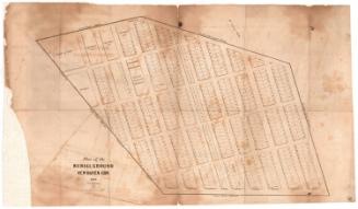
Map of the Ecclesiastical Society of New Britain in the Town of Farmington, Connecticut, 1758
DraftsmanDrawn by
Max J. Unkelbach
(American, 1877 - 1938)
Date1933
MediumLithography; black printer's ink on wove paper
DimensionsPrimary Dimensions (image height x width): 10 3/4 x 9 1/8in. (27.3 x 23.2cm)
Sheet (height x width): 11 3/4 x 9 7/8in. (29.8 x 25.1cm)
ClassificationsGraphics
Credit LineGift of the Heirs of Morgan B. Brainard
Object number1960.93.22
DescriptionMap of a portion of Farmington, Connecticut, comprising the Ecclesiastical Society of New Britain. The map is divided into three parts, separated by broken solid lines marking the boundaries between the old Farmington and Newington Societies and the old Farmington and Kensington Societies. The top section is labeled "Stanley Quarter" and the bottom, "Hart Quarter." Local roads are shown and some of them are labeled. Squares mark the residences of property owners and are labeled with the owner's name.
Label TextThe Congregational Church was a driving force behind the formation of many new towns in Connecticut. This map, drawn in 1933 by Max J. Unkelbach, a New Britain architect and civil engineer, shows the area that would eventually become the town of New Britain as it appeared in 1758. Stanley Road, running north and south between East Street and Main Street, would eventually become known as Stanley Street. In the twentieth century, Route 9 would cut between Stanley Street and Main Street, near the meeting house. The distance to the Farmington meeting house and the inconvenience that this posed to local churchgoers had caused New Britain to be established as a separate parish within the town of Farmington in 1754. New Britain was not incorporated as a separate town until 1850.
NotesCartographical Scale: No scaleStatus
Not on view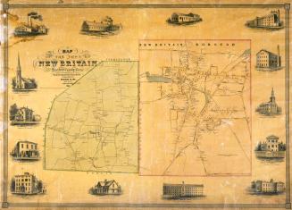


Silvermine Production
1973