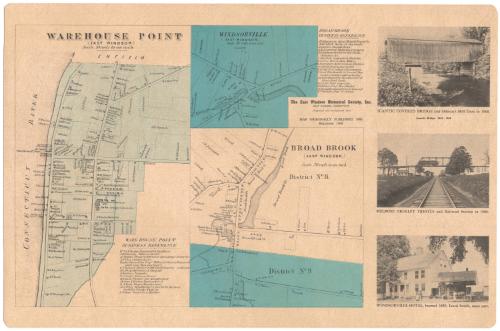
Warehouse Point, East Windsor
PublisherPublished by
East Windsor Historical Society
(American, founded 1965)
Date1966
MediumLithography; black and blue printer's ink on plastic-coated paper
DimensionsPrimary Dimensions (image height x width): 10 x 16 3/4in. (25.4 x 42.5cm)
Sheet (height x width): 11 1/2 x 17 1/2in. (29.2 x 44.5cm)
Sheet (height x width): 11 1/2 x 17 1/2in. (29.2 x 44.5cm)
ClassificationsGraphics
Credit LineConnecticut Museum of Culture and History collection
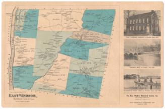
DescriptionPlacemat map of Warehouse Point in East Windsor, Connecticut, from the town line of Enfield to the north and the Connecticut River to the west. Owned land is denoted with solid boundary lines and labeled with the owner's name and a rectangle representing a building. Below the map to the right is a business reference list. Smaller maps of Windsorville, Broad Brook and District 9 are also shown, with similar indications of property ownership. There is a list of business references for Broad Brook. On the right side of the map are three photographs, one of the Scantic covered bridge and Osborn's Mill Dam, one of the Melrose trolley trestle and railroad station, and the other of the Windsorville Hotel and Louis Smith's meat cart.
Object number1992.142.2
NotesCartographic Note: 1 inch equals 30 rodsOn View
Not on view