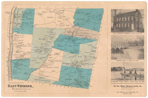
East Windsor, Hartford County, Connecticut
PublisherPublished by
East Windsor Historical Society
(American, founded 1965)
Date1966
MediumLithography; black and blue printer's inks on plastic-coated paper
DimensionsPrimary Dimensions (image height x width): 10 5/8 x 16 7/8in. (27 x 42.9cm)
Sheet (height x width): 11 1/2 x 17 1/2in. (29.2 x 44.5cm)
ClassificationsGraphics
Credit LineConnecticut Museum of Culture and History collection
Object number1992.142.1
DescriptionPlacemat map of East Windsor, Connecticut, from the town line of Enfield to the north, Tolland County to the east, South Windsor to the south, and the Connecticut River to the west. It is divided into 12 numbered districts, marked with broken solid boundary lines. Local roads are shown but not labeled, and are lined with small black squares representing buildings, which are labeled with the owner's name. On the right are three images, the first of East Windsor Academy, the second of Osborn's Mill, and the third of Warehouse Point Ferry.
Label TextThe East Windsor Historical Society was established in 1965. This placemat, with a reproduction of a map from Baker & Tilden's 1869 atlas of Hartford County, was evidently an early fundraising efforts; the placemats were available to members of the historical society as early as February 1966. Maps on placements are usually a form of advertising, though they are sometimes issued for educational purposes. This placemat was probably intended to interest local East Windsor residents in the history of their town.
NotesCartographic Note: Scale: 2 inches equal 1 mileStatus
Not on view