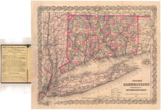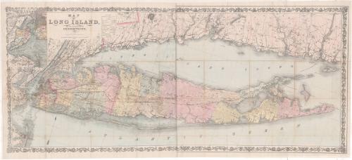
Map of Long Island, and the Southern Part of Connecticut
PublisherPublished by
G.W. & C.B. Colton & Co.
(American, founded 1865)
Date1866
MediumLithography; black printer's ink and watercolor on paper, lined with paper
DimensionsPrimary Dimensions (image height x width): 22 1/4 x 51 5/16in. (56.5 x 130.3cm)
Sheet (height x width): 23 3/4 x 52 3/8in. (60.3 x 133cm)
Mount (height x width): 23 3/4 x 52 3/8in. (60.3 x 133cm)
ClassificationsGraphics
Credit LineThe Newman S. Hungerford Museum Fund
Object number2013.46.0
DescriptionMap of Long Island, New York, and southern Connecticut, emphasizing the counties and towns on Long Island. County seats, villages with post offices, and villages are the populated areas shown. City streets are depicted in Manhattan; Brooklyn; New Haven; and Lakeland and Hermanville, Long Island. Churches and meeting houses are represented with symbols. Railroads depicted include the Long Island, Harlem, and New York and New Haven Railroads. Projected railroads are also shown. Other kinds of transportation infrastructure depicted include turnpike roads, post roads and canals. Mills and factories are also pictured, mostly along rivers. In the top left corner is an inset map of the New York Harbor and Bay, with water depth noted. Natural features depicted include elevation, conveyed through hachure marks; forests; and swampland.
Label TextThis large and attractive map of Long Island Sound suggests the ongoing importance of that body of water for the people of Connecticut and their ongoing connection with the people of Long Island on the opposite side of the Sound. Transportation of people and goods by steamships and sailing vessels continued to play an important role throughout the nineteenth century, and Long Island Sound continued to be a rich fishing ground for small fishing boats operating out of both Connecticut and New York State. This map also shows considerable detail on both shores, recording a coast that was due to change significantly during bad storms in the next century.
NotesCartographic Note: Scale: About 3/8 inches equals 1 mileStatus
Not on view