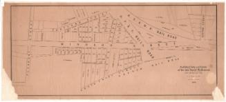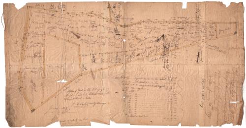
A plan of Wood in lots Belonging to Mr. John L. Lambert, Situate North of the Episcopal Church in Wilton
SurveyorSurveyed by
John S. Taylor
(American, 1795 - 1877)
DraftsmanDrawn by
John S. Taylor
(American, 1795 - 1877)
Date1829
MediumDrawing; black ink and watercolor on wove paper, linen strips on side edges
DimensionsPrimary Dimensions (image height x width): 15 3/8 x 29in. (39.1 x 73.7cm)
Sheet (height x width): 15 3/8 x 29in. (39.1 x 73.7cm)
ClassificationsGraphics
Credit LineConnecticut Museum of Culture and History collection
Object number2010.445.0
DescriptionMap of 61 land lots in Wilton, Connecticut, up for sale in 1829 for the wood they contained. Each lot is numbered, contains what is presumably the name of the purchaser, and the price for which it sold. In a list below the map, the sizes of the lots in acres, rods and perches. On the right side near the edge the terms of the sales are listed, including when the wood had to be removed.
Label TextJohn James Lambert was a prominent citizen and landowner in Wilton, Connecticut during the early nineteenth century. The Lambert family had been loyalists during the American Revolution and remained staunch supporters of the Episcopal Church in their hometown. In 1815, Lambert gave one acre of land on the Danbury Road to establish an Episcopal cemetery. This map shows land belonging to Lambert located north of the Episcopal Church. It is divided into wood lots, which Lambert evidently leased to his fellow citizens. Wood was the principal source of fuel in the early nineteenth century and most families still cut their own firewood.
NotesCartographic Note: Scale: 1 inch equals 6 rodsStatus
Not on view