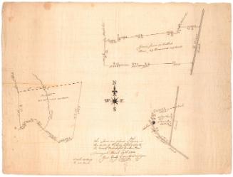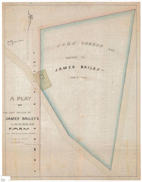
A Plat of the East Section ofJoseph Bailey's Lands, or Farm in Sterling, Connecticut
SurveyorSurveyed by
William C. Stanton
(American, 1807 - 1877)
DraftsmanDrawn by
William C. Stanton
(American, 1807 - 1877)
Date1848
MediumDrawing; watercolor on wove paper
DimensionsPrimary Dimensions (image height x width): 21 3/4 x 16 3/4in. (55.2 x 42.5cm)
Sheet (height x width): 22 1/2 x 17 5/8in. (57.2 x 44.8cm)
ClassificationsGraphics
Credit LineMuseum purchase
Object number1969.42.3
DescriptionPlat map of a land lot in Sterling, Connecticut, belonging to James Bailey. The land is located at the corner of two unnamed roads and is measured in feet and rods. Along the left side is a leased lot that is partly inside the Bailey lot and partly outside; on it stands the Bailey Schoolhouse. Another building, labeled "James Bailey," appears at the top left.
Label TextIn 1834, the plot of land in Sterling, Connecticut shown here, formed part of the estate of Archibald Gordon, who had died the previous year.. By 1848, the property had passed to John Gordon, who appears to have been Archibald's son, and John deeded it to James Bailey, who owned the adjoining lot. A smaller plot of land, which included a schoolhouse, straddled the two pieces of property, appears on both maps.
NotesCartographic Note: Scale: 1 inch equals 40 feetStatus
Not on view