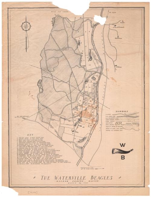
The Waterville Beagles
DraftsmanDrawn by
Unknown
Date1939
MediumLithography; black printer's ink on wove paper
DimensionsPrimary Dimensions (image height x width): 17 x 12 15/16in. (43.2 x 32.9cm)
Sheet (height x width): 18 1/4 x 14in. (46.4 x 35.6cm)
ClassificationsGraphics
Credit LineGift of Ethel Davis
Object number2006.121.0
DescriptionMap of a portion of Avon, Connecticut, with farmland to the north, the Farmington River to the east, the road to Unionville to the south, and Pine Woods Pond to the west. The map details the land features, using different lines to denote woods, marshes, orchards, brush, and ponds, with fields appearing as blank spots. Lines representing wire fences separate the various parcels of land. Roads are shown as two parallel lines, and a dry canal bed is also depicted. Most of the land is numbered on the map and labeled in a list in the lower left corner.
Label TextHunting with beagles is a popular sport in Great Britain has attracted some followers in the United States. There appears to have been an upsurge of interest in beagling around 1930, when Connecticut boasted at least three beagle packs, in New Canaan, Suffield, and Avon, which competed at the Hartford Dog Show in that year. The Waterville Beagle came in third in that competition. This 1939 map shows the area of Avon west of the Farmington River where the Beagles apparently hunted. Most of the land is fields, pastures, and woodlands.
NotesCartographic Note: Scale: 1 inch equals 600 feetStatus
Not on view

Silvermine Production
1973