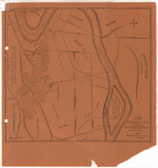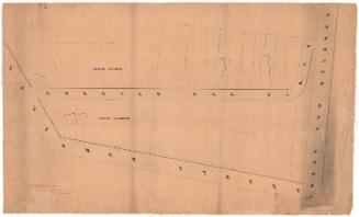
17th Century Wethersfield, Connecticut
MakerCompiled by
Arthur C. Willard
(American, 1876 - 1958)
DraftsmanDrawn by
W. Dudley Birmingham
(American, 1920 - 2005)
After a work byAfter a work by
Sherman Wolcott Adams
(American, 1836 - 1898)
Date1951
MediumLithography; brown printer's ink on wove paper
DimensionsPrimary Dimensions (image height x width): 16 5/8 x 22 3/8in. (42.2 x 56.8cm)
Sheet (height x width): 17 1/2 x 23in. (44.5 x 58.4cm)
Sheet (height x width): 17 1/2 x 23in. (44.5 x 58.4cm)
ClassificationsGraphics
Credit LineMuseum purchase
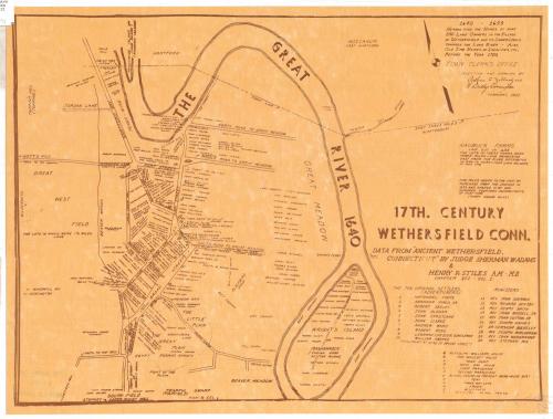
DescriptionMap of the town of Wethersfield, Connecticut, as it appeared in the seventeenth century. It extends from the Hartford line to the north, the Great River (Connecticut) to the east, the "Fearful Swamp" to the south, and the Great West Field to the west. The names of landowners are shown in the town center and on Wright's Island, and there is a list near the Great Meadow of landowners whose site locations are unknown. Symbols and letters are used on the map to denote the locations of historic places, which are listed in the bottom right corner. The ten original settlers and ten ministers are listed below the cartouche.
Object number1981.144.2
NotesCartographic Note: No scaleOn View
Not on view