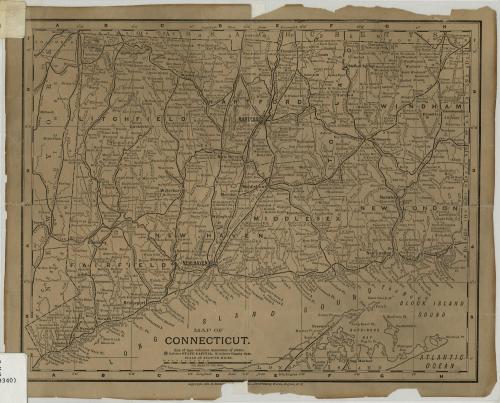
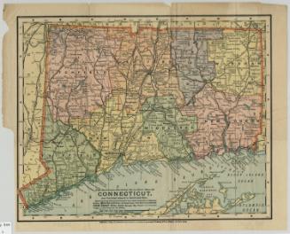
Map of Connecticut
PrinterPrinted by
Matthews-Northrup Company
(American)
Date1886
MediumLithography; black printer's ink on wove paper
DimensionsPrimary Dimensions (image height x width): 9 5/8 x 12 1/8in. (24.4 x 30.8cm)
Sheet (height x width): 10 1/2 x 13 1/8in. (26.7 x 33.3cm)
Sheet (height x width): 10 1/2 x 13 1/8in. (26.7 x 33.3cm)
ClassificationsGraphics
Credit LineConnecticut Museum of Culture and History collection
DescriptionMap of the state of Connecticut, from the border of Massachusetts to the north, Rhode Island to the east, the north shore of Long Island and the Long Island Sound to the south, and New York to the west. Thick black lines mark the railroads that run through the state: the New York, New Haven and Hartford; Danbury and Norwalk; Housatonic; Shepaug; New England, and New York; New Haven and Northampton; Connecticut Western; Hartford and Connecticut Valley; New London Northern; and New York, Providence and Boston. The state is divided into counties, marked with broken solid and dotted lines. Cities are labeled, with the size of the type indicating the "importance" (or size) of the place. Rivers are shown and labeled. Elevation is conveyed through hachure marks.
On the back of the map is information about products offered through The Mercantile Agency, the company that offered state maps in reference books to its subscribers. There is also a list of Mercantile Agency offices across the United States and Canada.
On the back of the map is information about products offered through The Mercantile Agency, the company that offered state maps in reference books to its subscribers. There is also a list of Mercantile Agency offices across the United States and Canada.
Object number2006.120.0
NotesCartographic Note: 1 inch equals 8 1/2 milesOn View
Not on view
Matthews-Northrup Company
1913