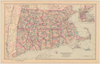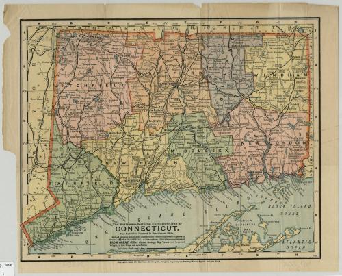
Up to Date Map of Connecticut
PrinterPrinted by
Matthews-Northrup Company
(American)
Date1898
MediumLithography; colored printer's inks on wove paper
DimensionsPrimary Dimensions (image height x width): 9 5/8 x 12in. (24.4 x 30.5cm)
Sheet (height x width): 10 3/4 x 13 1/2in. (27.3 x 34.3cm)
ClassificationsGraphics
Credit LineMuseum purchase
Object number1928.8.2
DescriptionMap of Connecticut, with part of Massachusetts is to the north, part of New York State is to the west, Long Island Sound and part of Long Island are to the south, and a small part of Rhode Island is the east. Counties are shown in different colors; cities and towns are indicated in larger or smaller type to suggest their relative size. Railroads and rivers, lakes, and ponds figure prominently. Numerous islands and points along Long Island Sound are identified. Only a few major hills, including West Rock, Mount Carmel, and Talcott Mountain, are indicated. Elevation is suggested by hachure marks.
Label TextThe Matthews-Northrup Company proudly advertised this 1898 map as an "Up to Date Map of Connecticut." Being up-to-date was always a desirable quality in maps and for much of the nineteenth century presented a real challenge to mapmakers, as new towns were added and canals and railroads were built. By 1898, this frenetic pace of development had sllowed slightly. The last new town to be incorporated before this map was published was Ansonia, incorporated in 1889. Nevertheless Matthews-Northrup did manage to convey a great deal of detailed information in a clear and concise manner. The map claimed to include "great cities, big towns, important villages, little villages, and mere stations," and did include many small places that don't always appear on maps of this size.
NotesCartographic Note:Status
Not on view

Matthews-Northrup Company
1913