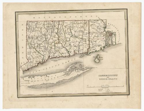
Connecticut and Rhode Island
PublisherPublished by
Thomas Gamaliel Bradford
(American, 1802 - 1887)
Date1835
MediumEngraving; black printer's ink and watercolor on wove paper
DimensionsPrimary Dimensions (image height x width): 7 3/4 x 10 1/8in. (19.7 x 25.7cm)
Platemark (height x width): 8 7/8 x 11 3/8in. (22.5 x 28.9cm)
Sheet (height x width): 9 1/2 x 12 1/2in. (24.1 x 31.8cm)
Platemark (height x width): 8 7/8 x 11 3/8in. (22.5 x 28.9cm)
Sheet (height x width): 9 1/2 x 12 1/2in. (24.1 x 31.8cm)
ClassificationsGraphics
Credit LineMuseum purchase
DescriptionMap of Connecticut and Rhode Island, with Massachusetts to the north and east, Long Island and the Long Island Sound to the south, and New York to the west. Connecticut is outlined in red with its counties outlined in green; Rhode Island is outlined in green with its counties outlined in red. Towns are marked with circles. The two proposed railroads depicted are one route between Waterford, Connecticut to the Massachusetts border, and between Stonington, Connecticut and Providence, Rhode Island. The Farmington Canal and the Blackstone Canals are shown as finished canals, with one proposed canal appearing in the northwest corner of Connecticut. Physical features include elevation, conveyed with hachure marks, rivers, ponds, and islands.
Object number1979.96.4
NotesCartographic Note: Scale: 1 inch equals 15 milesOn View
Not on view


Object/Object