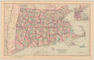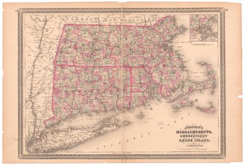
Johnson's Massachusetts, Connecticut and Rhode Island
PublisherPublished by
Alvin Jewett Johnson
(American, 1827 - 1884)
Date1864
MediumLithography; printer's ink and watercolor on wove paper
DimensionsPrimary Dimensions (image height x width): 16 7/8 x 23in. (42.9 x 58.4cm)
Sheet (height x width): 18 x 26 1/2in. (45.7 x 67.3cm)
ClassificationsGraphics
Credit LineMuseum purchase
Object number1979.96.3
DescriptionMap of Massachusetts, Connecticut, and Rhode Island, with portions of New York State to the west, Vermont and New Hampshire to the north, Massachusetts Bay and Cape Cod Bay to the east, and Long Island and the Atlantic Ocean to the south. Towns, counties, railroads, major rivers, and lighthouses are shown. An inset map shows the city of Boston and surrounding towns.
Label TextThe Johnson whose name appears so prominently in the title of this map is Alvin Jewett Johnson (1827-1884). Johnson started out as a door-to-door book salesman in the mid-West, then went to New York and started his own publishing company. This map of Massachusetts, Connecticut and Rhode Island formed part of Johnson's Family Atlas, which was sold by subscription, with canvassers going door-to-door, just as Johnson himself used to do. The atlas went through numerous editions, which were updated every year with new up-to-date maps gradually replacing the old maps, which Johnson had acquired from J. H. Colton & Co. This map appeared in the 1864 edition.
NotesCartographic Note: 2 7/8 inches = 30 milesStatus
Not on view