British Provinces
PrinterPrinted by
Bingham & Kelly
(American, 1857 - 1859)
PublisherPublished by
O. D. Case
(American, 1826 - 1903)
Date1857
MediumLithography; black printer's ink and watercolor on paper, lined with linen
DimensionsPrimary Dimensions (image height x width): 22 3/4 x 27 1/2in. (57.8 x 69.9cm)
Sheet (height x width): 24 3/4 x 29in. (62.9 x 73.7cm)
Mount (height x width): 25 1/4 x 29 1/2in. (64.1 x 74.9cm)
ClassificationsGraphics
Credit LineMuseum purchase
Object number1972.36.55.3
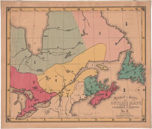
DescriptionOutline map of the eastern part of Canada, from Hudson's Bay to the north, Newfoundland to the east, the Great Lakes to the south, and what was Upper Canada (modern-day Ontario) to the west. The land is not labeled; instead, it is divided into seven numbered sections. There are also smaller numbers and circles that correspond with a key published separately from the map. Natural features include rivers and islands.
Label TextThis map of the British Provinces in North America shows what would later become Eastern Canada divided into seven regions identified as Hudson's Bay Territory (1), Labrador (2), Upper Canada (3), Lower Canada (4), New Brunswick (5), Nova Scotia (6), and Newfoundland (7). Upper and Lower Canada (corresponding to modern Ontario and Quebec) had been combined into a single province, the Province of Canada, in 1841, but that change is not reflected in this 1857 map.
NotesCartographic Note: Scale: About 3/4 inches equals 50 milesConstituent Note: Mitchell's Series of Outline Maps were first issued in 1841 by Mather, Case, Tiffany & Burnham of Hartford, Connecticut and Augustus Mitchell of Philladelphia.. In 1857, the maps were updated and resissued. This time the printing was done by a new lithography firm, Bingham & Kelly and the maps and the accompanying key were published by O.D. Case & Co., both in Hartford.
Status
Not on view