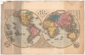
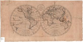
The World
PrinterPrinted by
Bingham & Kelly
(American, 1857 - 1859)
PublisherPublished by
O. D. Case
(American, 1826 - 1903)
Date1857
MediumLithography; black printer's ink and watercolor on paper, lined with linen
DimensionsPrimary Dimensions (image height x width): 27 1/2 x 47 7/8in. (69.9 x 121.6cm)
Sheet (height x width): 29 1/4 x 49 5/8in. (74.3 x 126cm)
Mount (height x width): 29 3/4 x 50in. (75.6 x 127cm)
ClassificationsGraphics
Credit LineMuseum purchase
Object number1972.36.55.1
DescriptionMap of the world, divided into the Eastern and Western Hemispheres. Between the two hemispheres is an illustration of seventeen numbered peaks, arranged in height order, two with smoke coming from their tops. Next to the peaks are a bird and a parachute. In the top left and right corners are insets of spheres showing the Arctic and Antarctic Circles and the Tropics of Cancer and Capricorn, with the inset on the left also showing the Equator and prime meridian. In the bottom left and right corners are insets showing the world from the south pole (on the left) and the north pole (on the right). The continents are distinguished by color. None of the countries are labeled; instead, they are identified with numbers and letters that correspond with information in the key, published separately from the map. Natural features include elevation, conveyed through hachure marks; deserts, conveyed through clusters of dots; lakes and rivers.
Label TextThe Key to the 1857 edition of Mitchell's Outline Maps included thirteen pages of questions about the map of the World, for the use of teachers who were using the maps to teach geography to their students. These questions were not only intended to teach basic facts about the composition of the globe, but also about the "stages of society" and government. "Enlightened" nations, such as the United States, are noted for their "intelligence, industry and their great skill in the arts and sciences. They are also more courteous than other nations, and treat their females with respect and politeness."
NotesCartographic Note: No scaleConstituent Note: Mitchell's Series of Outline Maps were first issued in 1841 by Mather, Case, Tiffany & Burnham of Hartford, Connecticut and Augustus Mitchell of Philladelphia.. In 1857, the maps were updated and resissued. This time the printing was done by a new lithography firm, Bingham & Kelly and the maps and the accompanying key were published by O.D. Case & Co., both in Hartford.
Status
Not on view