Borough of Willimantic in the Town of Windham
SurveyorSurveyed by
Ormando Willis Gray
(American, born 1829)
PrinterPrinted by
Kellogg & Bulkeley
(American, 1867 - 1990)
PrinterLetterpress by
Case, Lockwood and Brainard Company
(American)
PublisherPublished by
C. G. Keeney
(American, about 1810 - 1888)
Date1869
MediumLithography; black printer's ink and watercolor on wove paper
DimensionsPrimary Dimensions (image height x width): 16 1/8 x 27in. (41 x 68.6cm)
Sheet (height x width): 18 1/8 x 28 1/2in. (46 x 72.4cm)
ClassificationsGraphics
Credit LineConnecticut Museum of Culture and History collection
Object number2006.118.0
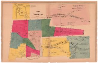
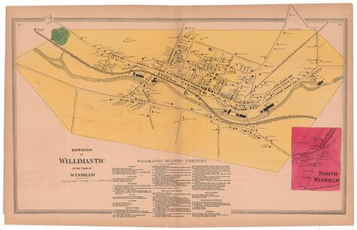
DescriptionMap of Willimantic, Connecticut, with Prospect Street to the north, Oak Street to the east, Pleasant Street to the south, and the cemetery to the west. The Willimantic River runs through the borough, with cotton and linen mills lining its banks. The Providence, Hartford and Fishkill; New London Northern; and Boston, Hartford and Erie Railroad lines also run through Willimantic. Private residences, businesses and public buildings are marked with black rectangles and are labeled with the owner or occupant's name. There is an inset map of North Windham in the bottom right corner of the sheet, which shows residences and a woolen factory, marked with black rectangles and labeled with the owner or occupant's name. Below the map is the Willimantic Business Directory, which lists the agents, carpenters, druggists, hotels, lawyers, manufacturers, merchants and dealers, meat markets, physicians and dentists, and jewelers.
Label TextThe village of Willimantic within the town of Windham rapidly developed into a major center of the textile industry with massive mills along the Willimantic River, far outstripping its parent community in population and prosperity. Willimantic was incorporated as a borough in 1833 and would be incorporated as a city in 1893. This map was part of an atlas of Windham and Tolland Counties printed and published in Hartford in 1869. The atlas was apparently not a success, since the surveyor soon moved on to Philadelphia, and the publisher is not known to have issued any other maps or atlases. The printer, Kellogg & Bulkeley, occasionally printed maps for local customers on into the twentieth century.
NotesCartographic Note: Scale: 1 inch equals 25 rodsConstituent Note: There is no imprint information on the map itself. Information regarding the surveyor, printers, and publisher of this map comes from the title page of the Atlas of Windham and Tolland Counties in which this map originally appeared.
Status
Not on view