1974 Map of Connecticut
PublisherPublished by
Connecticut Department of Transportation
(American, founded 1969)
PublisherPublished by
Connecticut Department of Commerce
(American, founded 1973)
PublisherPublished by
Connecticut Department of Environmental Protection
(American, founded 1971)
PublisherPublished by
Connecticut Department of Motor Vehicles
(American, founded 1917)
Date1974
MediumLithography; black and colored printer's inks on wove paper
DimensionsPrimary Dimensions (image height x width): 23 1/4 x 35 1/4in. (59.1 x 89.5cm)
Sheet (height x width): 24 x 36in. (61 x 91.4cm)
Sheet (height x width): 24 x 36in. (61 x 91.4cm)
ClassificationsGraphics
Credit LineConnecticut Museum of Culture and History collection
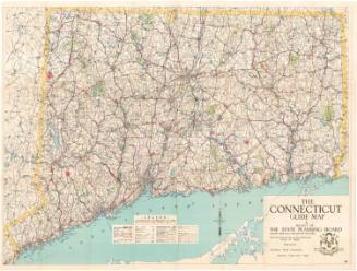
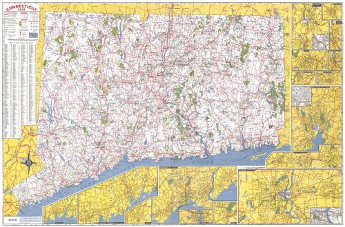
DescriptionMap of Connecticut, from Massachusetts to the north, Rhode Island to the east, the Long Island Sound to the south, and New York State to the west. A number of different types of roads are depicted, including multilane highways with and without tolls and dividers, two-lane highways and interchanges. State parks and forests are marked in green, and symbols denote the locations of rest areas, points of interest, boat launching sites, public fishing areas, ski areas and hunting areas. Airports, heliports, yacht clubs, fish hatcheries and information centers are also denoted with symbols. Cities are marked with circles of sizes that correspond to their population sizes.
Vignettes of Waterbury, Torrington, Ansonia/Derby/Shelton, Meriden, Middletown, Wallingford, Willimantic, New Haven, Bristol/New Britain, Hartford, Bridgeport, Norwich, New London/Groton, Danbury, Stamford/Norwalk, and Greenwich appear around the right and bottom borders.
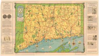
On the back of the map are 36 color photographs of different parts of Connecticut, showing its natural features, coastal scenes, festivals, and historic sites. A map of the state's Charter Oak Trail, with numbered points of interest along the way, is shown above information detailing Connecticut's outdoor recreational sites and facilities. Under the heading "Convenient Information Listing," state parks, forests and monuments are listed, along with information about tolls paid on highways, bridges, and ferries; a guide to expressway service signs; and information about railroad passenger stations. A mileage chart is located at the bottom of the sheet.
Vignettes of Waterbury, Torrington, Ansonia/Derby/Shelton, Meriden, Middletown, Wallingford, Willimantic, New Haven, Bristol/New Britain, Hartford, Bridgeport, Norwich, New London/Groton, Danbury, Stamford/Norwalk, and Greenwich appear around the right and bottom borders.
On the back of the map are 36 color photographs of different parts of Connecticut, showing its natural features, coastal scenes, festivals, and historic sites. A map of the state's Charter Oak Trail, with numbered points of interest along the way, is shown above information detailing Connecticut's outdoor recreational sites and facilities. Under the heading "Convenient Information Listing," state parks, forests and monuments are listed, along with information about tolls paid on highways, bridges, and ferries; a guide to expressway service signs; and information about railroad passenger stations. A mileage chart is located at the bottom of the sheet.
Object number2012.312.264
NotesCartographic Note: Scale: About 1 inch equals 1 1/2 milesOn View
Not on view