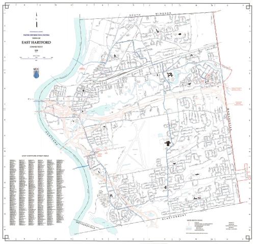
Town of East Hartford Water Distribution System
MakerPrepared by
Metropolitan District Commission
(American, founded 1929)
Date1998
MediumLithography; colored printer's inks on wove paper
DimensionsPrimary Dimensions (image height x width): 30 1/2 x 32in. (77.5 x 81.3cm)
Sheet (height x width): 31 1/4 x 32 1/2in. (79.4 x 82.6cm)
ClassificationsGraphics
Credit LineConnecticut Museum of Culture and History collection
Object number2012.312.263
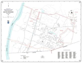
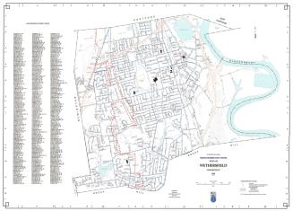
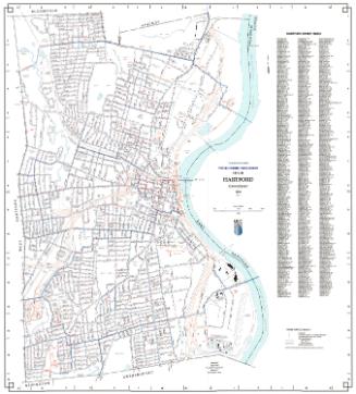
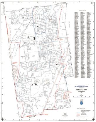
DescriptionMap of the town of East Hartford, Connecticut with South Windsor to the north, Manchester to the east, Glastonbury and a small section of Wethersfield to the south, and the Connecticut River to the west. Streets, interstate highways and highway intersections, railroads, streams (including the Hockanum River), and ponds are shown with water mains indicated in blue and red. A Water Service Legend at lower right provides a key to hydrants, hydrants subject fo pumped pressure, gate valves (sixteen inch main or larger), MDC water mains (less than six inches in diameter, six to twenty-three inches in diameter, and twenty-four inches or larger in diameter), and private water mains. Also shows the East Hartford Water Pollution Control Facility and Rentschler Field. An index of East Hartford streets is at lower left.
Label TextEast Hartford was the first town east of the Connecticut River to join the Metropolitan District Commission. It did so in 1941, just before the outbreak of World War II, a period during which the town was experiencing extraordinary growth due to the presence if Pratt & Whitney Aircraft, one of the largest defense industries in the nation. To meet Pratt & Whitney's huge demand for water, the MDC constructed a large water main running two miles from Wethersfield Avenue in Hartford to Main Street, East Hartford, crossing beneath the Connecticut River. This large twenty-four inch main still appears on this 1998 map.
NotesCartographic Note: One inch equals 1000 feetStatus
Not on view