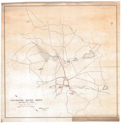
Colchester Water Works
SurveyorSurveyed by
Erastus Worthington
(American, 1863 - 1953)
Datebefore 1888
MediumDrawing; black and red ink on tracing linen
DimensionsPrimary Dimensions (image height x width): 33 1/4 x 34 1/8in. (84.5 x 86.7cm)
Sheet (height x width): 35 1/2 x 36 3/4in. (90.2 x 93.3cm)
Sheet (height x width): 35 1/2 x 36 3/4in. (90.2 x 93.3cm)
ClassificationsGraphics
Credit LineConnecticut Museum of Culture and History collection
DescriptionMap of Colchester, Connecticut and surroundings showing a proposed water distribution system with a pumping station to the north drawing on a wetland, a standpipe to the south on Dublin Hill, and water mains with gates and hydrants. The system serves the center of Colchester, including Pine Street, portions of North and South Main Street, Hayward Avenue, High Street, Mill Street, Park Street, and portions of Hall Hill Road and the Norwich Turnpike. Also shown are the Hayward Rubber Company, Bacon Academy, a hotel, the Post Office, Linwood Cemetery, and the Colchester branch of the New York, New Haven and Hartford Railroad. Outlying roads and streams are not named. An arrow indicates that the map is oriented with north towards the lower right corner.
Object number2012.312.241
NotesCartographic Note: One inch equals 660 feet
Date Note: The Hayward Rubber Company, which appears on this map, closed in 1885. Its buildings were taken over by the Colchester Rubber Company in 1888. If this map were later than 1888, one would expect the name to appears as the Colchester Rubber Company.On View
Not on view