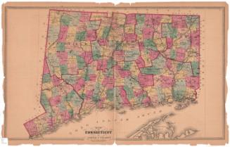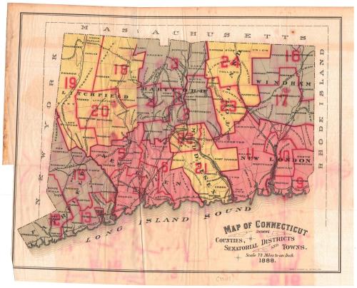
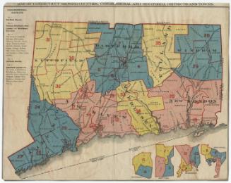
Map of Connecticut Showing Counties, Senatorial Districts and Towns
PrinterPrinted by
Kellogg & Bulkeley
(American, 1867 - 1990)
Date1888
MediumLithograph; black and colored printer's inks on wove paper
DimensionsPrimary Dimensions (image height x width): 10 7/8 x 13 3/4in. (27.6 x 34.9cm)
Sheet (height x width): 11 7/8 x 14 7/8in. (30.2 x 37.8cm)
Sheet (height x width): 11 7/8 x 14 7/8in. (30.2 x 37.8cm)
ClassificationsGraphics
Credit LineGift of Debra Lenentine
DescriptionMap of Connecticut, with the border of Massachusetts to the north, Rhode Island to the east, the Long Island Sound to the south, and New York to the west. The state is divided into counties, which are labeled and outlined in solid red and black lines; towns, which are labeled and outlined in broken solid lines; and 35 senatorial districts, which are numbered and outlined in red lines. Inset maps in the lower right corner depict the Waterbury, Hartford, Bridgeport, and New Haven districts. To the left of the map is a list of the congressional districts. Railroads depicted include the New York, New Haven and Hartford; Danbury and Norwalk; Housatonic; New York and New England; Shepaug; Hartford and Connecticut Western; Boston and New York Air Line; New Haven and Northampton; New London Northern; and Norwich and Worcester Railroads.
Object number2005.185.0
NotesCartographic Note: Scale: 1 inch equals 7 1/2 milesOn View
Not on view
Kellogg & Bulkeley
1910-1915
Kellogg & Bulkeley
1915-1920