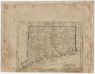
Connecticut
PublisherPublished by
John Warner Barber
(American, 1798 - 1885)
Date1849
MediumEngraving; black printer's ink and watercolor on wove paper
DimensionsPrimary Dimensions (image height x width): 7 3/8 x 9 1/4in. (18.7 x 23.5cm)
Sheet (height x width): 8 7/8 x 11in. (22.5 x 27.9cm)
ClassificationsGraphics
Credit LineMuseum purchase
Object number1938.37.1
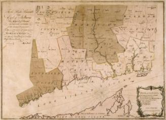
DescriptionMap of Connecticut, with the border of Massachusetts to the north, Rhode Island to the east, part of Long Island and the Long Island Sound to the south, and New York to the west. The state is divided into counties that are outlined in broken solid and dotted lines and labeled, and towns that are outlined in dotted lines and labeled. Population centers appear to be denoted with open circles. Elevation is depicted with clustes of peaks. Railroads and what appear to be local roads are shown. Many small rivers are shown in addition to the Connecticut, Stratford (Housatonic), Thames and Quinebaug Rivers. Harbors, points, islands, and ponds are also depicted.
Label TextJohn Warner Barber's Connecticut Historical Collections was first published in 1836, and remains a valuable resource for information on Connecticut towns to this day. Barber researched and wrote the text for the book, drew and engraved on wood all of the illustrations for it, and published it himself. Immensely popular, it went through several editions in the nineteenth century and was reprinted in the twentieth century. This map was folded into an early edition of the book. Barber made a conscientious attempt to incorporate all the latest information. This map includes the town of Eastford, incorporated in 1847, and the town of Andover, incorporated in 1848, and therefore probably accompanied the 1849 edition. For that edition, Barber redrew and updated several of the illustrations to reflect changes that had taken place since 1836.
NotesCartographic Note: Scale: 1 inch equals about 11 milesStatus
Not on view