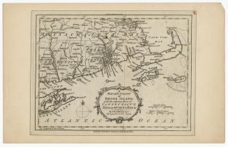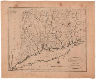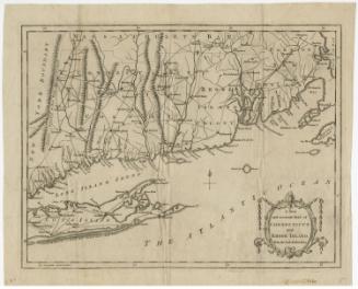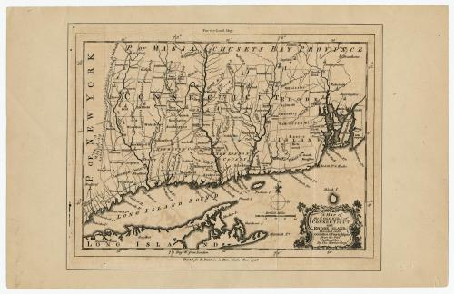
A Map of the Colonies of Connecticut and Rhode Island
PrintmakerEngraved by
Thomas Kitchin
(British, 1719 - 1784)
PublisherPublished by
R. Baldwin
(British, active 1749 - 1810)
Date1758
MediumEngraving; black printer's ink on laid paper, with wove paper mount
DimensionsPrimary Dimensions (image height x width): 6 3/4 x 9 1/8in. (17.1 x 23.2cm)
Sheet (height x width): 7 1/4 x 9 3/8in. (18.4 x 23.8cm)
Mount (height x width): 8 5/8 x 13 1/2in. (21.9 x 34.3cm)
Sheet (height x width): 7 1/4 x 9 3/8in. (18.4 x 23.8cm)
Mount (height x width): 8 5/8 x 13 1/2in. (21.9 x 34.3cm)
ClassificationsGraphics
Credit LineMuseum purchase
DescriptionMap of colonial Connecticut and Rhode Island, with Massachusetts Bay Province to the north and east, part of Long Island and the Long Island Sound to the south, and New York to the west. In Connecticut, Fairfield, New Haven and New London counties are labeled, as are the towns in the state. Rhode Island is divided into towns, which are labeled. Symbols mark the locations of churches or other public gathering spaces. Rivers, islands, points and elevation (shown with clusters of peaks) are the natural features shown.
Object number1946.17.1
NotesCartographic Note: Scale: About 1 1/4 inches equals 20 milesOn View
Not on view