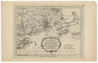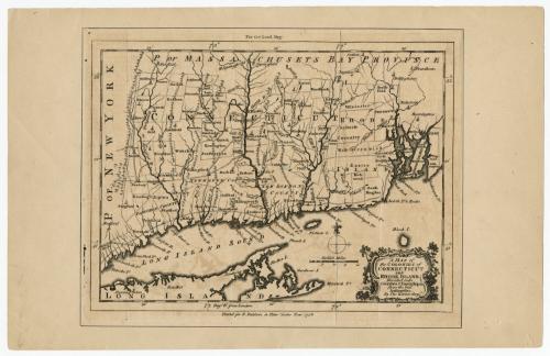
A Map of the Colonies of Connecticut and Rhode Island
PrintmakerEngraved by
Thomas Kitchin
(British, 1719 - 1784)
PublisherPublished by
R. Baldwin
(British, active 1749 - 1810)
Date1758
MediumEngraving; black printer's ink on laid paper, with wove paper mount
DimensionsPrimary Dimensions (image height x width): 6 3/4 x 9 1/8in. (17.1 x 23.2cm)
Sheet (height x width): 7 1/4 x 9 3/8in. (18.4 x 23.8cm)
Mount (height x width): 8 5/8 x 13 1/2in. (21.9 x 34.3cm)
ClassificationsGraphics
Credit LineMuseum purchase
Object number1946.17.1
DescriptionMap of colonial Connecticut and Rhode Island, with Massachusetts Bay Province to the north and east, part of Long Island and the Long Island Sound to the south, and New York to the west. In Connecticut, Fairfield, New Haven and New London counties are labeled, as are the towns in the state. Rhode Island is divided into towns, which are labeled. Symbols mark the locations of churches or other public gathering spaces. Rivers, islands, points and elevation (shown with clusters of peaks) are the natural features shown.
Label TextThis small engraved map by Thomas Kitchin appeared in the London Magazine in April 1758. Despite its small size, it is an extremely important early map of Connecticut, the first map known to focus on the entire state. It was probably based on a general map of New England which appeared in Thomas Jefferys's American Atlas, published in London in 1755. Kitchin was responsible for a series of fifty-six maps that were published in the London Magazine between 1747 and 1760.
NotesCartographic Note: Scale: About 1 1/4 inches equals 20 milesStatus
Not on view