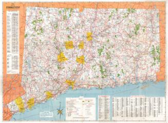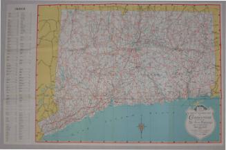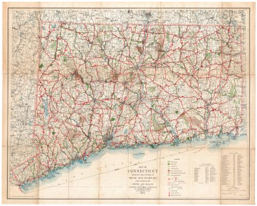
Map of Connecticut Showing the System of Trunk Line Highways and Connecting State Aid Roads Together with Other Information of General Interest
PublisherPublished by
Connecticut State Highway Department
(American, 1895 - 1969)
PrinterPrinted by
A. Hoen & Company
(American, founded 1848)
Date1934
MediumLithography black and colored printer's inks on wove paper
DimensionsPrimary Dimensions (image height x width): 21 1/2 x 26 7/8in. (54.6 x 68.3cm)
Sheet (height x width): 22 5/8 x 28in. (57.5 x 71.1cm)
ClassificationsGraphics
Credit LineGift of Martin A. Gilman
Object number2001.192.4
DescriptionMap of Connecticut, from Massachusetts to the north, Rhode Island to the east, the Long Island Sound to the south, and New York to the west. It shows the "trunk line" system of highways, both improved and unimproved, numbered on the map. State aid roads, state forests and parks, fish hatcheries, state game sanctuaries, state leased shooting grounds, state leased streams, airports, light houses, airport beacons, and highway picnic areas are also shown. Below the map are the legend, a list of state forests and a list of state parks.
Label TextSweeping changes in the numbering of state highways in Connecticut took place in 1932, part of a four-state agreement affecting New York, Massachusetts, and Rhode Island, as well as Connecticut. This simplified numbering system was intended to make it easier for motorists to find their way around the state, but the changes must have been confusing to those familiar with the old numbering system. The State issued new road maps free of charge to familiarize residents and travelers with the new route numbers. By and large, the new route numbers which appear on this 1934 map are those that remain in use in the early twenty-first century.
NotesCartographic Note: Scale: 1 inch equals 4 milesStatus
Not on view