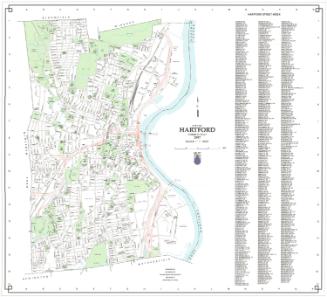
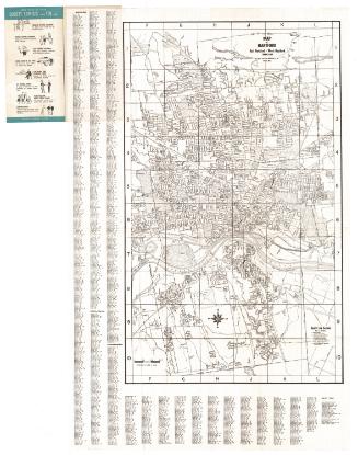
Map of the City of Hartford
DraftsmanDrawn by
Frederick B. Chamberlain
(American, born 1892)
PublisherPublished by
LaCroix Publishing Company
(American, 1944 - 1955)
Date1953
MediumLithography; black printer's ink on wove paper, in booklet with paper covers
DimensionsPrimary Dimensions (image height x width): 11 3/8 x 16in. (28.9 x 40.6cm)
Sheet (height x width): 12 3/8 x 17 1/4in. (31.4 x 43.8cm)
Sheet (height x width): 12 3/8 x 17 1/4in. (31.4 x 43.8cm)
ClassificationsGraphics
Credit LineGift of Martin A. Gilman
DescriptionPocket map of Hartford, Connecticut, oriented east-west on the sheet with the Connecticut River at the bottom. Streets are labeled. Parks are shown with shading and shapes indicating trees. Other spaces, such as schools, hospitals, and Brainard Airport are similarly shaded. The New York, New Haven and Hartford Railroad runs through the city. Physical features include the Park River. On the back is a similar map of West Hartford and a street index. The sheet is folded into the National Blue Guide to Hartford, which includes information about traffic regulations, population, churches, and clubs.
Object number2001.192.2
NotesCartographic Note: Scale: 1 inch equals 1000 feetOn View
Not on view