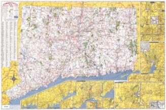
The Connecticut Guide Map
PublisherPublished by
Emergency Relief Commission
(American, 1933 - 1937)
Date1935
MediumLithography; black and colored printer's inks on wove paper
DimensionsPrimary Dimensions (image height x width): 28 3/4 x 38 7/8in. (73 x 98.7cm)
Sheet (height x width): 30 1/8 x 40in. (76.5 x 101.6cm)
ClassificationsGraphics
Credit LineGift of Martin A. Gilman
Object number2001.192.1
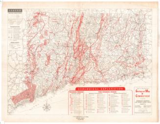
DescriptionMap of Connecticut, from the border of Massachusetts to the north, Rhode Island to the east, the north shore of Long Island and the Long Island Sound to the south, and New York State to the west. Four- and two-lane state roads are depicted in red, with four- and two-lane state aid roads in green and unimproved state roads in red and white. Other roads are shown as two parallel lines, and scenic roads as parallel lines with black dots between them. U.S. and state highways are numbered. Other kinds of transportation infrastucture depicted include ferry routes, railroads, airports and lighthouses. The locations of "scenic places" and "good views" are denoted with symbols, as are historic buildings, forts and battlefields, sites of Native American history and industrial history, old mines and quarries, and areas of geological or botanical interest. The sizes of the names of cities correspond to their population, with larger cities appearing in larger type.
Label Text"Everyone who owns an automobile should have a copy of the Connecticut Guide and its accompanying map...in his car for handy reference..." Thus the Hartford Courant extolled the Connecticut Guide Map, a road map specifically designed for travellers, both Connecticut residents and out-of-state visitors. In an age before the Interstates, Connecticut was criss-crossed by a network of two- and four-lane roads and "other" roads, including back roads ideal of a Sunday drive. The symbols on the map corresponded to entries in the guide book, which encouraged exploration by providing information about places of interest throughout the state.
NotesCartographic Note: Scale: 3/8 inches equals 1 mileStatus
Not on view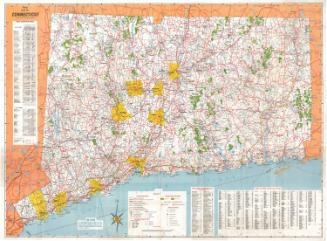

Connecticut State Highway Department
1923