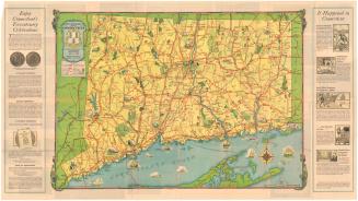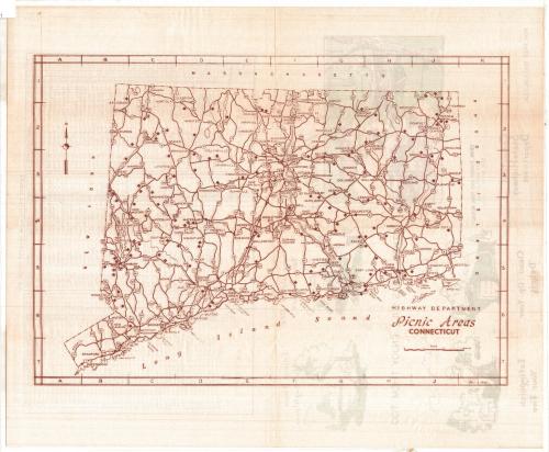
Picnic Areas, Connecticut
PublisherPublished by
Connecticut State Highway Department
(American, 1895 - 1969)
DistributorDistributed by
Connecticut Forest and Park Association
(American, founded 1895)
Date1954
MediumSerigraphy and halftone; brown and green ink on wove paper
DimensionsPrimary Dimensions (image height x width): 10 1/2 x 15in. (26.7 x 38.1cm)
Sheet (height x width): 14 x 17in. (35.6 x 43.2cm)
ClassificationsGraphics
Credit LineConnecticut Museum of Culture and History collection
Object number1985.209.0
DescriptionOutline map of Connecticut showing the location of roadside picnic areas along federal and state highways. A key is provided which corresponds to a list of picnic areas on the verso, which gives the location of each picnic area and indicates the facilities (fireplaces, toilets, water) available. Illustrations on the verso show a couple in a convertible at a picnic area, a typical sign, and directions to extinguish fires and clean up debris at picnic areas “so that other users can enjoy them too.” Also on the verso is a list of the picnic areas, its grid location, and whether it has fireplaces, toilets and water.
Label TextIn the decades following World War II, Americans took to the road in their automobiles in ever increasing numbers as the highway system expanded and new superhighways were built. This map of highway picnic tables was published by the Connecticut State Highway Department to encourage Connecticut citizens to explore the byways of their state. The back of the map includes hints on how to use and enjoy these roadside rest areas.
NotesCartographic Note: Scale: 5/8 inches equals 5 milesStatus
Not on view
Connecticut State Highway Department
1934