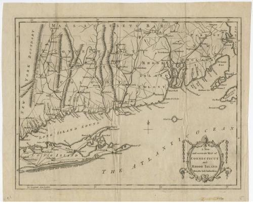
A New and Accurate Map of Connecticut and Rhode Island
DraftsmanDrawn by
Unknown
PublisherPublished by
Universal Magazine
(British, 1747 - 1814)
Date1780
MediumEngraving; printer's ink on wove paper
DimensionsPrimary Dimensions (image height x width): 10 1/4 x 13 3/8in. (26 x 34cm)
Platemark (height x width): 10 1/2 x 13 1/2in. (26.7 x 34.3cm)
Sheet (height x width): 12 x 14 5/8in. (30.5 x 37.1cm)
ClassificationsGraphics
Credit LineGift of William C. Conklin
Object number1971.71.9
DescriptionMap of Connecticut and Rhode Island with the New York border to the west, Massachusetts to the north, Cape Cod Bay to the east, and the Atlantic Ocean south of Long Island to the south. Towns, rivers, and roads are indicated. Mountains and hills are shown by rows of peaks. "Lands granted by New York to Connecticut" are labeled at the left. A four point compass rose appearswest of Block Island, which is identified as Block Rock Island. Many place names are misspelled. An elaborate cartouche with rococo decorations is at the lower right.
Label TextThis "New and Accurate" map of Connecticut is not very accurate. The courses of the major rivers are incorrectly shown, and other information is quite sketchy. The gravest error, however, lies in the longitude, which places Connecticut at 53 to 56 degrees west of London, somewhere in the middle of the Atlantic Ocean. The calculation of longitude--east-west position--had long posed a challenge to navigators and mapmakers; but the error in this case is likely one of simple fact-checking. Moses Park had made the same error in his 1766 map of Connecticut, which probably served as the direct source for this one, which was published in the Universal Magazine in London in 1780.
NotesCartographic Note: No scaleStatus
Not on view