New England States
PublisherPublished by
H. & F. J. Huntington
(American, 1830 - 1832)
Date1830
MediumEngraving; printer's ink on wove paper
DimensionsPrimary Dimensions (image height x width): 16 x 9 5/8in. (40.6 x 24.4cm)
Sheet (height x width): 17 7/8 x 10 7/8in. (45.4 x 27.6cm)
ClassificationsGraphics
Credit LineGift of William C. Conklin
Object number1971.71.8
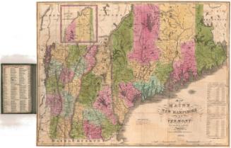
DescriptionMap of the New England states of Maine, New Hampshire, Vermont, Massachusetts, Connecticut, and Rhode Island from Lake Saint John and the Saint Lawrence River to the north; Passamaquoddy Bay to the east; the Atlantic Ocean south of Long Island to the south; and the eastern part of New York state to the west. Distances from Boston are indicated at the right. An explanation shows how CAPITALS, Chief Towns, and Small Towns are indicated on the map. Longitude is given east from Washington.
Label TextMany small sailing vessels, all of them accurately depicted, ply the waters of Long Island Sound and the Atlantic Ocean in this 1830 map. Some are labeled: "Coasting Vessels going to and from New York," "Vessel going to India," "Vessel going to England," "Whaling Vessel going to the North Seas," suggesting the nature and extent of New England's maritime commerce in this period. The Farmington Canal, which was enjoying its brief heyday, is also shown, connecting New Haven and Northampton. Most transportation was still by water at this date, but this would begin to change within the decade, with the building of the first railroads.
NotesCartographic Note: 1 5/8 inches = 60 milesStatus
Not on view