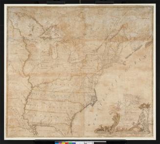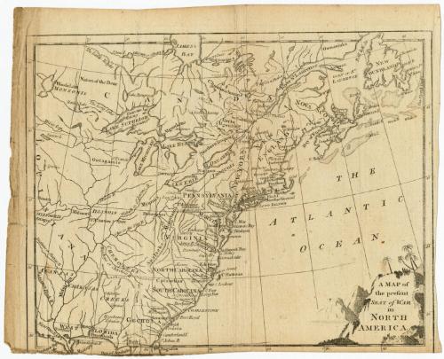
A Map of the present Seat of War in North America
PublisherPublished by the
Westminster Magazine
(British, 1773 - 1785)
Date1776
MediumEngraving; black printer's ink on laid paper
DimensionsPrimary Dimensions (image height x width): 7 5/8 x 9 5/8in. (19.4 x 24.4cm)
Sheet (height x width): 8 1/4 x 10 1/4in. (21 x 26cm)
Sheet (height x width): 8 1/4 x 10 1/4in. (21 x 26cm)
ClassificationsGraphics
Credit LineGift of William C. Conklin
DescriptionMap of north America east of what was then Louisiana, with Canada to the north, the Atlantic Ocean to the east, and West Florida to the south. The land west of the thirteen colonies is labeled with the names of the Native American tribes that lived there, and rivers are depicted and labeled. The thirteen colonies and eastern Canadian provinces are presented in a bit more detail, with dotted lines denoting boundaries and population centers indicated with open circles and labels. Elevation is conveyed through clusters of peaks. A double parallel line runs from Boston down to St. Augustine and is probably a road. The cartouche is decorative and features palm trees and mountains rising out of a body of water.
Object number1971.71.7
NotesCartographic Note: No scaleOn View
Not on view