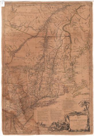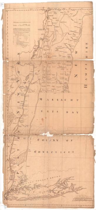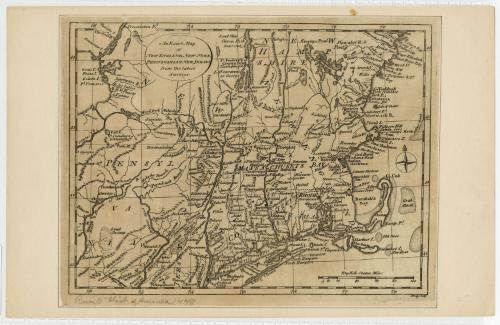
An Exact Map of New England, New York, Pennsylvania & New Jersey from the latest Surveys
PrintmakerEngraved by
John Lodge
(British, died 1796)
Date1778
MediumEngraving; printer's ink on paper
DimensionsPrimary Dimensions (image height x width): 7 1/2 x 10in. (19.1 x 25.4cm)
Sheet (height x width): 8 x 10 3/8in. (20.3 x 26.4cm)
Mount (height x width): 8 5/8 x 13 1/2in. (21.9 x 34.3cm)
Sheet (height x width): 8 x 10 3/8in. (20.3 x 26.4cm)
Mount (height x width): 8 5/8 x 13 1/2in. (21.9 x 34.3cm)
ClassificationsGraphics
Credit LineGift of William C. Conklin
DescriptionMap of the states of Connecticut, Massachuetts, and Rhode Island, with parts ot the states of Pennsylvania, New York, New Jersey, and New Hampshire. The eastern part of Lake Ontario and the Susquehanna River are to the west. Nazareth, Pennsylvania; Newark, New Jersey; and New York, New York are to the south. Jeffreys Bank, Crab Bank and other unnamed banks are to the east. The northern part of Lake Champlain and Casco Bay are to the north. Various forts, including Fort Frederick, Fort Ticonderoga, Fort George, Fort Dummer, Fort Miller, Fort Handy, Fort Shirley, and Fort Anne, are indentified. A four-point compass rose is at the far right.
Object number1971.71.1
NotesCartographic Note: 2 5/8 inches = 100 English statute miles. An English statue mile equals 5280 feet.On View
Not on view