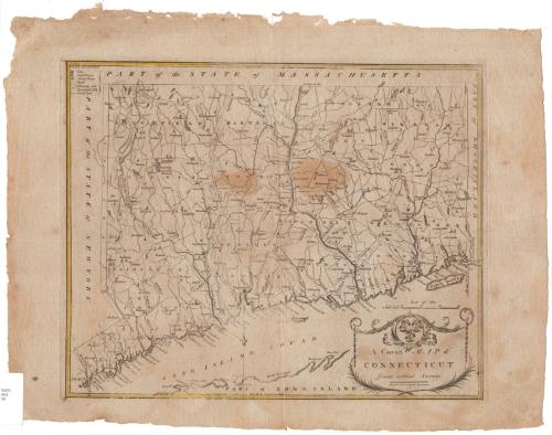
A Correct Map of Connecticut from actual Survey
PrintmakerEngraved by
Amos Doolittle
(American, 1754 - 1832)
Date1797
MediumEngraving; black priinter's ink and watercolor on paper
DimensionsPrimary Dimensions (image height x width): 13 x 16in. (33 x 40.6cm)
Platemark (height x width): 13 3/8 x 16 1/2in. (34 x 41.9cm)
Sheet (height x width): 16 1/8 x 20 3/4in. (41 x 52.7cm)
Platemark (height x width): 13 3/8 x 16 1/2in. (34 x 41.9cm)
Sheet (height x width): 16 1/8 x 20 3/4in. (41 x 52.7cm)
ClassificationsGraphics
Credit LineGift of Mrs. Hokan B. Steffanson
DescriptionMap of Connecticut, from Massachusetts to the north, Rhode Island to the east, part of Long Island and the Long Island Sound to the south, and New York State to the west. The state is divided into counties, which are labeled and delineated with broken solid lines. Cities are denoted on the map as cross-hatched squares and meeting houses and courthouses with little buildings. Natural features include elevation, depicted with hachure marks, rivers, ponds, harbors, islands and points. The cartouche features the state seal, with its three grapevines, and the state motto in Latin, "Qui transtulit sustinet" ("He who transplanted still sustains.")
Object number1947.20.1
NotesCartographic Note: Scale: 1 1/2 inches equals 10 miles
On View
Not on view

Joel Knott Allen
1791 or 1792

