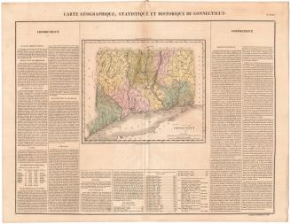
Geographical, Statistical, and Historical Map of Connecticut
PrintmakerEngraved by
Young & Delleker
(American, 1822 - 1823)
PublisherPublished by
Carey & Lea
(American, founded 1822)
Date1827
MediumEngraving; black printer's ink and watercolor on wove paper
DimensionsPrimary Dimensions (image height x width): 9 5/8 x 11 5/8in. (24.4 x 29.5cm)
Platemark (height x width): 10 3/4 x 12 1/4in. (27.3 x 31.1cm)
Sheet (height x width): 17 5/8 x 22 3/8in. (44.8 x 56.8cm)
ClassificationsGraphics
Credit LineHoadley Fund
Object number1946.16.8
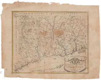
DescriptionMap of Connecticut, with Massachusetts to the north, Rhode Island to the east, Long Island and the Long Island Sound to the south, and New York to the west. The state is divided into counties that are labeled and delineated with broken solid lines, while towns are also labeled and delineated with dotted lines. Cities are marked with boxes. Elevation is conveyed with clusters of peaks that are shaded with hachure marks on one side, and other natural features include rivers, ponds, islands, harbors, and points. The map is surrounded by text blocks that describe Connecticut's physical features, population distribution, climate, higher education, government, and history.
Label TextEarly nineteenth-century atlas pages like this one were printed from engraved copper plates, and the plates were frequently passed from publisher to publisher as new firms took over the business of their predecessors. This map was engraved by the firm of James H. Young and George Delleker, who were only in business together in 1822 and 1823, but it appeared in an atlas published by Carey & Lea in Philadelphia in 1827. Not surprisingly, the towns of Orange, Manchester, Monroe, Madison, and Prospect, which were incorporated between 1822 and 1827, do not appear on this map, since the plate was not updated to reflect such changes.
NotesCartographic Note: Scale: 1/2 inch equals 5 milesStatus
Not on view