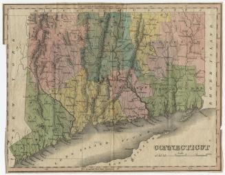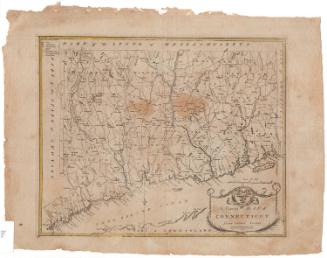
Geographical, Statistical, and Historical Map of Connecticut
PrintmakerEngraved by
Young & Delleker
(American, 1822 - 1823)
PublisherPublished by
H. C. Carey & I. Lea
(American, 1822 - 1835)
Dateprobably 1822
MediumEngraving; black printer's ink and watercolor on wove paper
DimensionsPrimary Dimensions (image height x width): 9 3/4 x 11 5/8in. (24.8 x 29.5cm)
Platemark (height x width): 10 3/4 x 12 3/8in. (27.3 x 31.4cm)
Sheet (height x width): 17 3/4 x 22 1/8in. (45.1 x 56.2cm)
ClassificationsGraphics
Credit LineHoadley Fund
Object number1946.16.7
DescriptionMap of Connecticut, with Massachusetts to the north, Rhode Island to the east, Long Island and the Long Island Sound to the south, and New York to the west. The state is divided into counties that are labeled and delineated with broken solid lines, while towns are also labeled and delineated with dotted lines. Cities are marked with boxes. Elevation is conveyed with clusters of peaks that are shaded with hachure marks on one side, and other natural features include rivers, ponds, islands, harbors, and points. The map is surrounded by text blocks that describe Connecticut's physical features, population distribution, climate, higher education, government, and history.
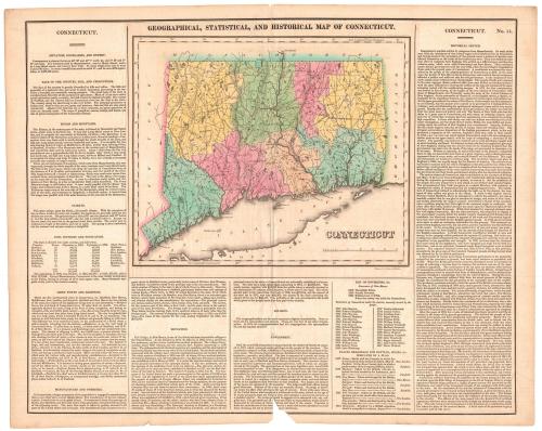
Label TextIn 1822, Henry Charles Carey and Isaac Lea published A Complete Historical, Chronological and Geographical American Atlas, which included this map of Connecticut. Nineteenth-century mapmakers tried to include as much information as possible in their maps. It was not unusual for state maps to incorporate population statisitcs, lists of governors, and similar historic facts. The maps in Carey's Atlas went even further. Each map was surrounded by paragraphs on Climate, Education, Manufactures and Commerce, Religion, and Government, together with a lenthy historical sketch, providing a comprehensive overview of the state.
NotesCartographic Note: Scale: 1/2 inch equals 5 milesStatus
Not on view