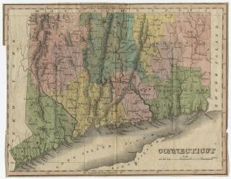
Connecticut
PrintmakerEngraved by
William Barker
(American, active 1792 - 1805)
Date1816?
MediumEngraving; black printer's ink and watercolor on paper
DimensionsPrimary Dimensions (image height x width): 5 1/2 x 7 1/2in. (14 x 19.1cm)
Platemark (width only): 8 1/8in. (20.6cm)
Sheet (height x width): 8 1/8 x 10 1/2in. (20.6 x 26.7cm)
ClassificationsGraphics
Credit LineHoadley Fund
Object number1946.16.6
DescriptionMap of the state of Connecticut, with Massachusetts to the north, Rhode Island to the east, the Long Island Sound to the south, and New York State to the west. The state is divided into counties that are labeled and delineated with dotted lines. Population centers appear to be denoted with open circles. Elevation is conveyed with clusters of peaks. Many small rivers are shown in addition to the Connecticut, Stratford (Housatonic), and Thames Rivers. Harbors, points, islands, and ponds are also depicted.
Label TextA scribbled note suggests that this map appeared in a General Atlas published by Carey & Warner in Philadelphia in 1816. If this map really was published in 1816, it was very badly out-of-date at the time of its publication. None of the towns that were incorporated in the first decades of the nineteenth century are included, and some towns, such as Branford appear with early spellings--in this case "Brentford"--which were unusual after 1800. Furthermore Connecticut's northern border is shown as a straight line, lacking the "Southwick Jog," the small piece of land granted to Massachusetts in 1797 in settlement of a boundary dispute.
NotesCartographic Note: Scale: 11/16 inches equals 10 milesDate Note: Though a pencil inscription indicated that this map appeared in an 1816 atlas, internal evidence suggests that a date in the 1790s is much more likely.
Status
Not on view