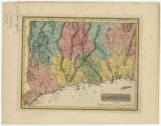
Connecticut
PrintmakerEngraved by
William Barker
(American, active 1792 - 1805)
PublisherPublished by
Mathew Carey
(American, 1760 - 1839)
Date1796
MediumEngraving; black printer's ink on wove paper
DimensionsPrimary Dimensions (image height x width): 5 5/8 x 7 1/2in. (14.3 x 19.1cm)
Platemark (height x width): 6 x 7 3/4in. (15.2 x 19.7cm)
Sheet (height x width): 6 3/8 x 8 1/4in. (16.2 x 21cm)
ClassificationsGraphics
Credit LineHoadley Fund
Object number1946.16.4
DescriptionMap of the state of Connecticut, with Massachusetts to the north, Rhode Island to the east, the Long Island Sound to the south, and New York to the west. The state is divided into counties that are outlined in dotted lines and labeled. Population centers appear to be denoted with open circles, and there are symbols that probably indicate the location of courthouses or town halls. Elevation is depicted with clustes of peaks. Many small rivers are shown in addition to the Connecticut, Stratford (Housatonic), Thames and Quinebaug Rivers. Harbors, points, islands, reefs and ponds are also depicted.
Label TextDriven by the desire to document the new nation, map publishers in the 1790s turned out a remarkable number of atlases, gazeteers, and individual maps. This small map from Mathew Carey's American Pocket Atlas (Philadelphia, 1796) was evidently based on Amos Doolittle's 1795 map of Connecticut. It closely follows that map, only omitting town lines because of its small scale. During this period, mapmakers often copied each other's work, relying on these secondary sources for information about parts of the country and world distant from their own.
NotesCartographic Note: Scale: 1 inch equals 10 milesStatus
Not on view