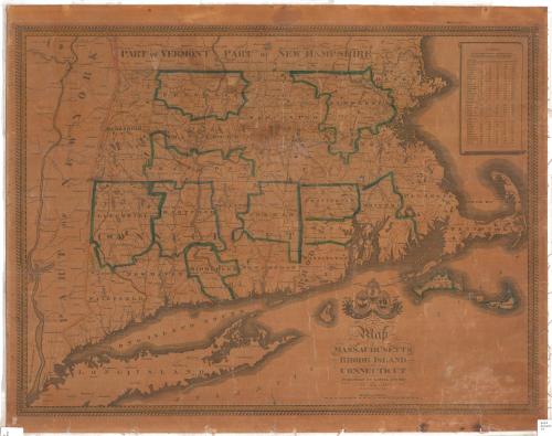
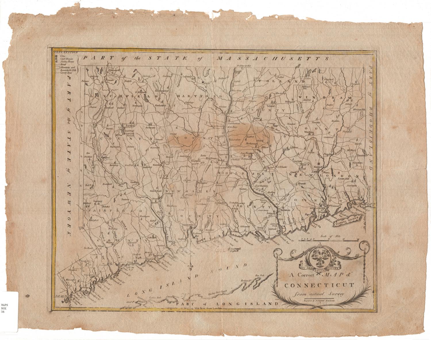
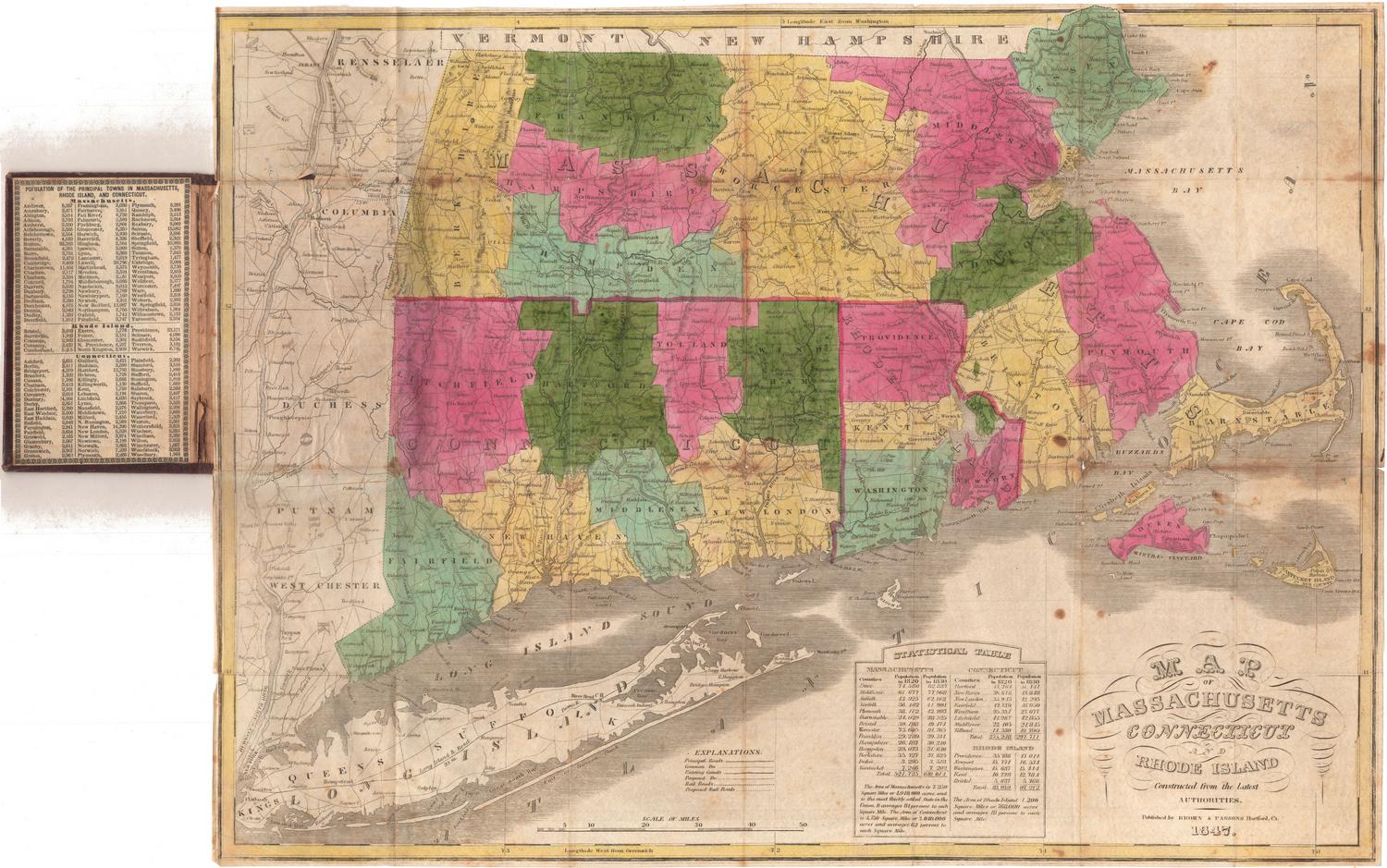
A Map of Massachusetts, Rhode Island and Connecticut
DraftsmanDrawn by
John Gould Darby
(American, 1808 - 1881)
PrintmakerEngraved by
John Gould Darby
(American, 1808 - 1881)
PublisherPublished by
Lemuel Bingham
(American)
Date1843
MediumEngraving; black printer's ink and watercolor on paper, lined with linen
DimensionsPrimary Dimensions (image height x width): 22 x 29 1/8in. (55.9 x 74cm)
Sheet (height x width): 24 x 30 1/8in. (61 x 76.5cm)
Mount (height x width): 24 x 30 1/8in. (61 x 76.5cm)
ClassificationsGraphics
Credit LineMuseum purchase
Object number1990.179.0
DescriptionMap of Massachusetts, Connecticut and Rhode Island, with the state borders of Vermont and New Hampshire to the north, the Atlantic Ocean to the east and south, and part of New York State to the west. The land is divided into counties, labeled and outlined with broken solid lines and colored pink or blue; and towns, labeled and outlined with solid black lines. Physical features depicted include mountains, conveyed through hachure marks; rivers, which are labeled; and lakes, some of which are labeled. To the right of the map is a table listing the distances between various towns in Massachusetts, Rhode Island and Connecticut and Boston, Providence, Hartford, New Haven and New York. Above the title text, the cartouche features the seals of the three states depicted; the Rhode Island and Connecticut seals also bear the states' mottos, "Hope," and "Qui transtulit sustinet," respectively. Above the Massachusetts seal is its state motto, "Ense petit placidam sub libertate quietem." Below the seals are two cornucopias or horns of plenty.
Label TextBy 1840, lithography had become the predominant method for map production, replacing the older, more-labor intensive practice of engraving on copper or steel. Nevertheless, some experienced engravers like John Gould Darby continued to use the earlier technique. Not only was the technique used for making this map old-fashioned when it was issued; the content of the map was out-of-date as well. Many new towns were added to Connecticut during the 1820s, 1830s, and 1840s. The town of Madison, incorporated in 1826, is the latest Connecticut town to appear. No less that ten towns were incorporated between 1826 and 1843, when the map was published. This suggests that plate was actually engraved in the mid-1820s before lithography became commonplace and simply reprinted in the 1840s without changes. Carefully checking place names and other information in other states may reveal further anachronisms.
NotesCartographic Note: Scale: 5 3/8 inches equals 40 milesStatus
Not on view

Lucius Stebbins & Co.
1859
Object/Object