Map of the Most Inhabited Part of New England
PrintmakerEngraved by
Unknown
After a work byAfter a work by
Georges Louis LeRouge
(French, 1707 - 1790)
PublisherPublished by
Unknown
Date1777
MediumEngraving; black printer's ink and watercolor on laid paper
DimensionsPrimary Dimensions (left side, part a, image height x width): 39 7/8 x 19in. (101.3 x 48.3cm)
Platemark (left side, part a, height only): 40 1/2in. (102.9cm)
Sheet (left side, part a, height x width): 41 1/4 x 20in. (104.8 x 50.8cm)
Primary Dimensions (right side, part b, image height x width): 39 3/4 x 21 3/8in. (101 x 54.3cm)
Platemark (right side, part b, height x width): 40 3/4 x 19 3/4in. (103.5 x 50.2cm)
Sheet (right side, part b, height x width): 43 1/2 x 21 3/8in. (110.5 x 54.3cm)
ClassificationsGraphics
Credit LineMuseum purchase
Object number1979.95.0a,b
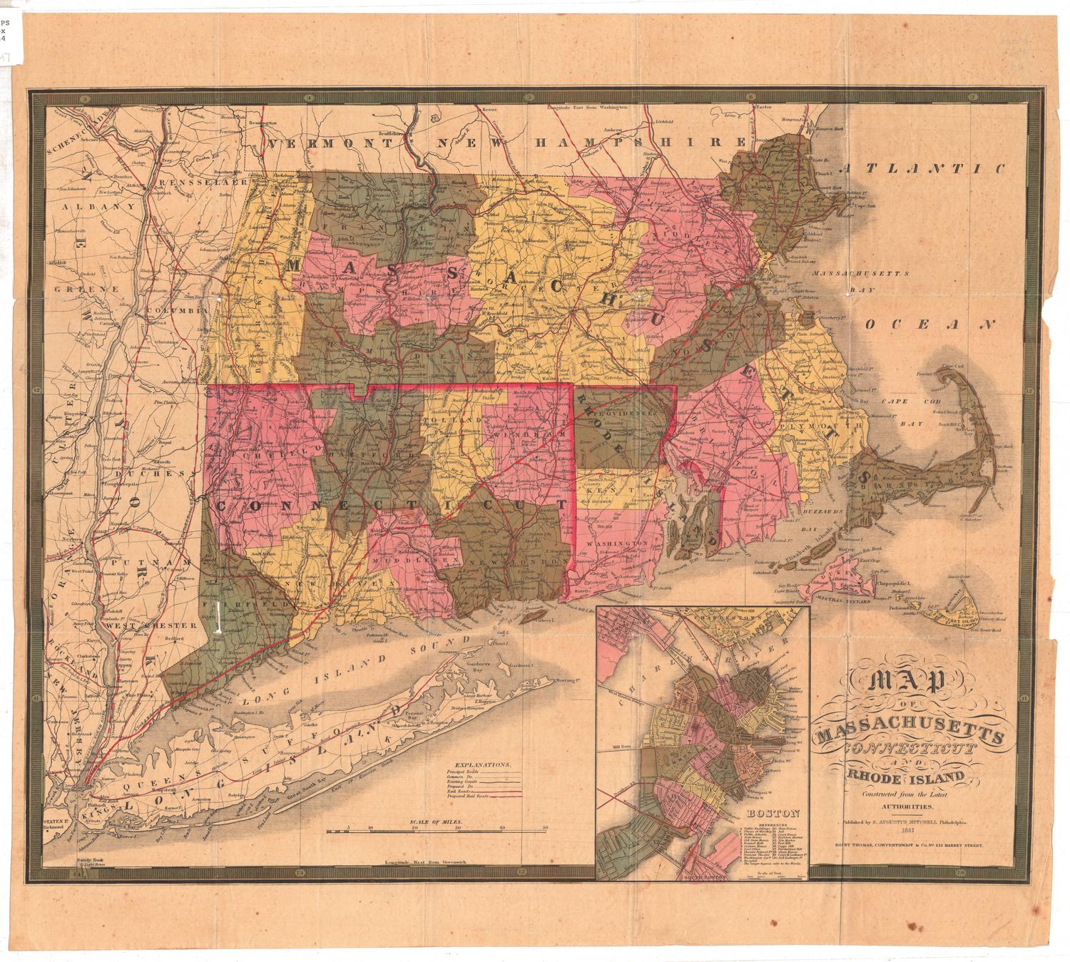
DescriptionMap in two pieces, showing New England and part of New York State, from what is now Vermont and New Hampshire to the north, the Atlantic Ocean to the east, Long Island and the Long Island Sound to the south, and New York State to the west. The states and provinces are divided into counties and towns, both labeled. Towns are divided with broken solid lines. Elevation is depicted with clusters of peaks. Shoals, banks and islands off the coastline of New England are marked. In the top left corner of the left piece, section a, is an inset map of Boston, showing local streets and landmarks. Letters on it correspond with a reference list of places located below the inset, and there are numbers that appear on it that do not seem to be related to anything in the reference list. In the bottom left corner of the right piece, section b, is an inset map of Boston Harbor, which shows the city of Boston and the surrounding islands. What are presumably water depths in fathoms are shown on this inset. The cartouche is decorative and depicts a scene labeled "Plymouth MDCXX [1620]." It shows a Native American wearing a loincloth and feathered headdress greeting a group of Pilgrims, their ship visible in the backgroud. An allegorical figure presumably meant to represent Liberty, holds a liberty cap on a pole.
Label TextGeorge Louis Le Rouge's Map of the Most Inhabited Part of New England was closely based on Thomas Jefferys's map with the same title. These important French and British maps were used by military officers on both sides during the American Revolution. According to the inscription in the cartouche, this map is a copy of Le Rouge's map, undoubtedly made by an English speaking mapmaker. Although many place names are given in French as well as in English, Le Rouge's Paris address, Rue des grands Augustins, is anglicized to Austin Street.
NotesCartographic Note: Main map scale: About 1/2 inch equals 1 marine league. Inset map of Boston scale: 3 1/2 inches equals 1 mile. Inset map of Boston Harbor scale: 2 1/8 inches equals 5 miles.Status
Not on view


Kellogg & Bulkeley
1910-1915