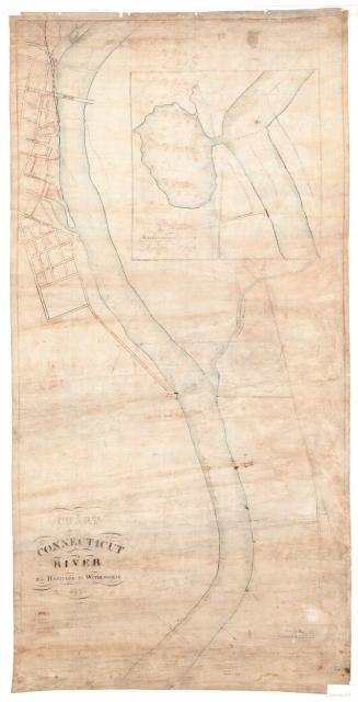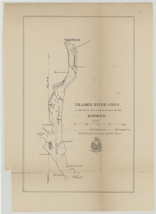
Thames River, Connecticut, showing the obstructions below Norwich
SurveyorSurveyed by
Unknown
PrinterPrinted by
Unknown
Dateabout 1910
MediumLithography; black printer's ink on wove paper
DimensionsPrimary Dimensions (image height x width): 9 x 5 11/16in. (22.9 x 14.4cm)
Sheet (height x width): 10 3/4 x 7 5/8in. (27.3 x 19.4cm)
ClassificationsGraphics
Credit LineMuseum purchase
Object number1982.129.3
DescriptionChart of the Thames River below Norwich, Connecticut, showing water depth, water curves, sandbars, coves, points, shoals and flats. The Shetucket River is located to the southeast of Norwich. Below the title is the seal and motto of the Army Corps of Engineers, featuring the Corps Castle with three towers, and the French word "essayons," or "let us try."
Label TextConnecticut's Thames River was an important waterway in the nineteenth and early twentieth century, with heavy steamboat traffic transporting passengers and freight to railheads at New London and Norwich. Regular dredging operations were necessary to maintain the channel and to remedy obstructions resulting from spring freshets and heavy accumulations of ice during the winters. This modest map may have been produced by the U. S. Army Corps of Engineers to accompany a report on such conditions, possibly to solicit funding from the federal government.
NotesCartographic Note: Scale: 2 3/8 inches equals 1 mileConstiuent Note: The "Engraving Bureau" whose imprint appears on this map may have been a federal agency.
Medium Note: The print is probably a transfer lithograph, even though there is an inscription that says it was engraved.
Status
Not on view
George W. Corliss