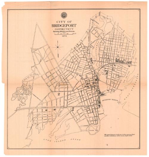
City of Bridgeport, Connecticut. Showing Altitudes and Sewers.
SurveyorSurveyed by
Unknown
Date1878
MediumLithography; black printer's ink on wove paper
DimensionsPrimary Dimensions (image height x width): 15 1/8 x 14 1/2in. (38.4 x 36.8cm)
Sheet (height x width): 16 5/8 x 15 7/8in. (42.2 x 40.3cm)
Sheet (height x width): 16 5/8 x 15 7/8in. (42.2 x 40.3cm)
ClassificationsGraphics
Credit LineMuseum purchase
DescriptionMap of Bridgeport, Connecticut, from North Avenue to the north, West Stratford to the east, the Long Island Sound to the south, and Mountain Grove Cemetery to the west. The city is divided into six numbered sections, possibly wards. Buildings are shown with shaded rectangles. Most of them are not labeled, with the exception of the railroad freight house, steamboat and railroad docks, and and horse car depot. The streets are named and many of them have numbers and "x"s inscribed near the intersections that represent the locations of sewers and elevation above mean high water. The New York, New Haven and Hartford railroad line runs through the city. The Pequonnock (Poquonock) River and Cedar Creek are also shown.
Object number1982.129.1
NotesCartographic Note: Scale: 2 inches equals 2400 feetOn View
Not on view