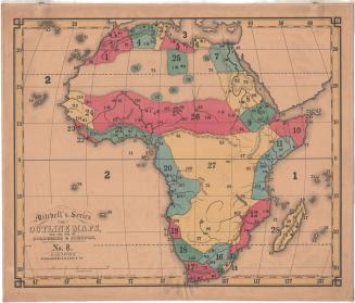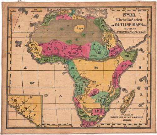
Africa
PrinterPrinted by
Mather, Case, Tiffany & Burnham
(American, active 1841)
Date1841
MediumLithography; black printer's ink and watercolor on paper, lined with linen
DimensionsPrimary Dimensions (image height x width): 23 x 27 5/8in. (58.4 x 70.2cm)
Sheet (height x width): 24 1/4 x 29in. (61.6 x 73.7cm)
Mount (height x width): 24 5/8 x 29 3/8in. (62.5 x 74.6cm)
ClassificationsGraphics
Credit LineConnecticut Museum of Culture and History collection
Object number2012.312.222.21
DescriptionMap of Africa. The countries are not labeled; instead, they are numbered. There are also smaller numbers and circles that correspond with a key published separately from the map. Natural features include elevation, depicted with hachure marks; deserts, depicted with clusters of dots; rivers and islands. In the bottom left corner is an inset map.
Label TextThe Key for Exercise on Mitchell's Series of Outline Maps provided an extensive list of questions for teachers to use when presenting this map of Africa to their students in a classroom setting. Surprisingly, the questions make no reference to slavery, but there is a lengthy section on Liberia, which appears as a separate inset in order to allow greater detail. These questions include "Under the auspices of what body in the United States was Liberia settled?" and "What is said of the climate?" the answers being "The American Colonization Society" and "Healthful to the natives."
NotesCartographic Note: No scaleStatus
Not on view