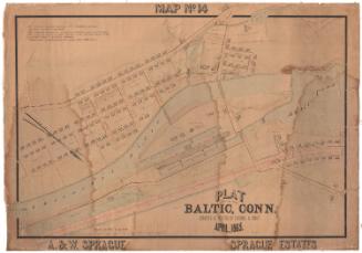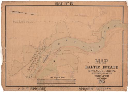
Map of the Baltic Estate in Sprague, Connecticut
SurveyorSurveyed by
Cushing & Dewitt
(American)
DraftsmanDrawn by
William E. Cushing
(American, 1845 - 1880)
Date1865
MediumDrawing; black and red ink and watercolor on wove paper, lined with linen
DimensionsPrimary Dimensions (image height x width): 27 1/16 x 39in. (68.7 x 99.1cm)
Sheet (height x width): 29 3/4 x 41 1/2in. (75.6 x 105.4cm)
Mount (height x width): 29 3/4 x 41 1/2in. (75.6 x 105.4cm)
ClassificationsGraphics
Credit LineConnecticut Museum of Culture and History collection
Object number2012.312.234
DescriptionMap of Sprague, Connecticut, showing parcels of land belonging to William Sprague near the Shetucket River and Baltic Pond. Each parcel is labeled with its measurements in feet and area in acres, sometimes with notes about when it was purchased by the A. & W. Sprague Manufacturing Company. Additions to the map appear in blue pen and detail the sale of land from private owners to the Baltic Power Company in 1898. The cotton mill buildings are visible on the left side of the map along the Shetucket River. The names of some of the nearby property owners are also shown.
Label TextIn 1856, William Sprague, Sr., of Cranston, Rhode Island, began what he described as "the largest mill on the Western Continent" in a rural part of eastern Connecticut, only to die later that year. Construction of the Baltic Cotton Mill was continued by his sons, A. & W. Sprague, and in 1861, the area was incorporated as the town of Sprague, with the mill village of Baltic in its southwest corner. This map shows the large cotton mill on the Shetucket River, the associated mill housing, and the large pond that provided water power. Additional notations on the map made in 1898 record the transfer of property to the Baltic Power Company, which continued to operate a mill on the site until 1967. The original mill was destroyed by fire in 1877.
NotesCartographic Note: Scale: 1 inch equals 300 feetStatus
Not on view