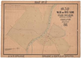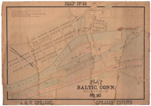
Plat of Baltic, Connecticut
SurveyorSurveyed by
Cushing & Dewitt
(American)
DraftsmanDrawn by
William E. Cushing
(American, 1845 - 1880)
Date1865
MediumDrawing; black and red ink and watercolor on wove paper, lined with linen
DimensionsPrimary Dimensions (image height x width): 29 1/8 x 41 1/2in. (74 x 105.4cm)
Sheet (height x width): 29 1/8 x 41 1/2in. (74 x 105.4cm)
Mount (height x width): 29 1/8 x 41 1/2in. (74 x 105.4cm)
ClassificationsGraphics
Credit LineConnecticut Museum of Culture and History collection
Object number2012.312.233
DescriptionMap of part of Baltic, Connecticut, where the Shetucket River and Baltic Pond connect. Oriented so that north points to the bottom right corner, the map shows the Stone Cotton Mill and its various buildings, mill housing, a saw mill, grist mill and woolen mill. Other buildings near Mill Pond include a store, a post office, a Baptist church, and Baltic House. In the bottom right section fo the map are a barn, farm house and an agent's house. The Hartford, Providence and Fishkill Railroad runs parallel to the Shetucket River, with the station on the right side of the map. The dimensions of land parcels and some buildings are provided, along with information about the owner and/or sale of the land to its then-current owner.
Label TextIn 1856, William Sprague, Sr., of Cranston, Rhode Island, began what he described as "the largest mill on the Western Continent" in a rural part of eastern Connecticut, only to die later that year. Construction of the Baltic Cotton Mill was continued by his sons, A. & W. Sprague, and in 1861, the area was incorporated as the town of Sprague, with the mill village of Baltic in its southwest corner. This map provides a detailed view of the large stone mill building, the associated mill housing, a small woolen mill, the Baptist church, and Baltic House, a hotel and tavern. Later land transactions, dating to 1903, are recorded in red.
NotesCartographic Note: Scale: 1 inch equals 100 feetStatus
Not on view