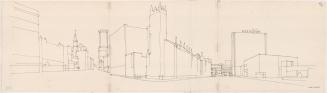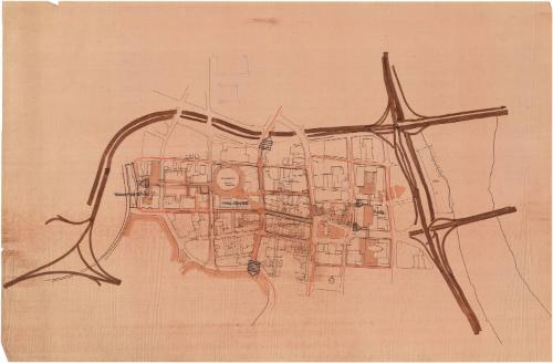
Plan of Hartford, showing the Hartford Civic Center
DraftsmanProbably drawn by
Harry J. Danos and Associates
(American, founded 1969)
Datebefore 1975
MediumDrawing; black ink and marker on wove paper
DimensionsPrimary Dimensions (image height x width): 19 1/2 x 36 1/8in. (49.5 x 91.8cm)
Sheet (height x width): 24 1/8 x 36 1/8in. (61.3 x 91.8cm)
Sheet (height x width): 24 1/8 x 36 1/8in. (61.3 x 91.8cm)
ClassificationsGraphics
Credit LineConnecticut Museum of Culture and History collection
DescriptionMap of the streets and buildings comprising downtown Hartford, Connecticut, with the Civic Center in the middle. The interstate highways that run through the city are shown but are not labeled. North of the Civic Center are two unnamed buildings sketched in pencil. Union Station is denoted with railroad tracks and is referred to as "Transportation." Many of the streets are labeled: Church, Asylum, Ann, Trumbull, Main, Pratt and Market. The three blocks between Trumbull and Main Streets are labeled "Commercial," and the area just east of Market Street is labeled "Plaza" and "Office." Arrows with one, two, or three bars are shown pointing in the four cardinal directions, with two arrows pointing east.
Object number2012.312.226
NotesCartographic Note: No scaleOn View
Not on view