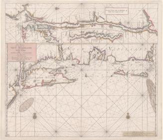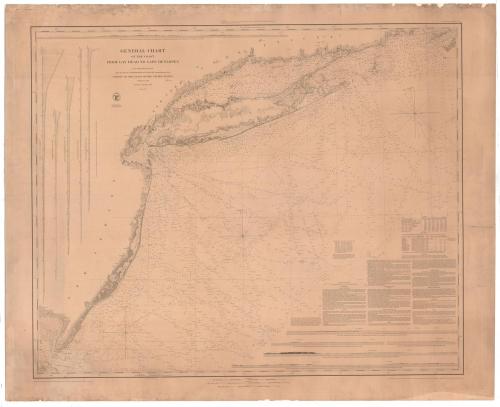
General Chart of the Coast from Gay Head to Cape Henlopen
SurveyorSurveyed by
Alexander Dallas Bache
(American, 1806 - 1867)
SurveyorSurveyed by
Ferdinand Rudolph Hassler
(American, 1770 - 1843)
PrintmakerElectrotyped by
George Mathiot
(American, died 1873)
PublisherPublished by
United States Coast Survey
(American, founded 1807)
Date1852
MediumElectrotype; black printer's ink on wove paper, lined with paper
DimensionsPrimary Dimensions (image height x width): 31 x 37 7/8in. (78.7 x 96.2cm)
Platemark (height x width): 33 3/4 x 41 3/8in. (85.7 x 105.1cm)
Sheet (height x width): 35 x 43in. (88.9 x 109.2cm)
Mount (height x width): 35 x 43in. (88.9 x 109.2cm)
ClassificationsGraphics
Credit LineConnecticut Museum of Culture and History collection
Object number2012.312.221
DescriptionChart of the coastlines of Delaware Bay, New Jersey, New York State and Long Island, and Connecticut, with Martha's Vineyard in the top right corner. The chart focuses on water depth in fathoms and ocean floor conditions, providing information about whether the ocean floor was sand, mud, ooze, clay, pebbles, and more, what color it was and its texture. Below the chart are several paragraphs of information containing sailing directions and two tables about tides and lighthouses. At the bottom of the sheet there are five views of the coastline, showing Block Island Sound, Navesink Highlands, Barnegat, the Delaware Bay with the Cape May lighthouse, and the Delaware Bay with the Cape Henlopen lighthouse. At the top left is a sixth view that shows the area south of Speonk, Long Island. On the left side of the sheet there are five charts showing water depth as it changes between two points.
Label TextThis chart of the Atlantic Coast from Gay Head on Martha's Vineyard, Massachusetts to Cape Henlope, Delaware, provides substantial detail for the waters of Long Island Sound and the Connecticut Coast. It would have been a useful navigational tool for coasting schooners and steamships between New York, Boston, and Connecticut ports such as Bridgeport, New Haven, New London, and Stonington. While steamships became the norm for passenger travel, sailing vessels continued to be used into the early twentieth century to transport heavy cargoes such as stone and timber.
NotesCartographic Note: Scale: 1:400,000Constituent Note: Ferdinand Rudolph Hassler and Alexander Dallas Bache employed a large number of assistants on this map. Bache succeeded Hassler as Superintendant of the United States Coast Survey.
Medium Note: In 1851, George Mathiot developed an electrotyping process which greatly increased the effiency and speed of map printing. This 1852 map is one of the first maps produced using this new process, which would prove of great importance in producing maps for military use during the Civil War.
Status
Not on view