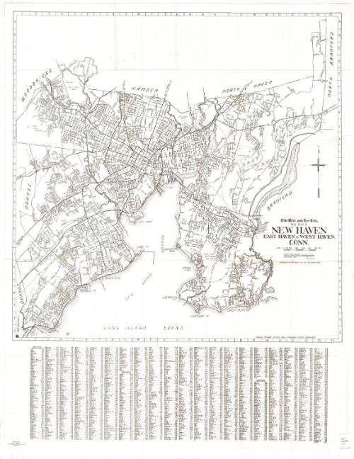
The Price & Lee Company's New Map of New Haven, East Haven and West Haven, Connecticut
PrinterPrinted by
R. A. Welcke Offset Co.
(American, active 1967)
PublisherPublished by
Price & Lee Co.
(American)
Dateprobably 1967
MediumOffset lithography; black printer's ink on wove paper
DimensionsPrimary Dimensions (image height x width): 23 5/8 x 23 3/4in. (60 x 60.3cm)
Sheet (height x width): 32 x 25in. (81.3 x 63.5cm)
ClassificationsGraphics
Credit LineConnecticut Museum of Culture and History collection
Object number2012.312.219
DescriptionMap of the towns of New Haven, East Haven and West Haven, extending from the boundary lines of Woodbridge, Hamden and North Haven to the north; Branford and North Branford to the east; the Long Island Sound to the south; and Orange to the west. City streets are labeled, and natural features such as Lake Saltonstall, Lake Phipps, and the Maltby Lakes; and the West, Quinnipiac and Farm Rivers. Parks and golf courses are labeled. The New York, New Haven and Hartford Railroad runs through town. Street indexes for all three towns are found below the map.
Label TextSurprisingly few landmarks appear on this 1960s map of New Haven, East Haven, and West Haven. Neither Yale University with its museums or any of the local businesses are indicated. Apparently the map was intended solely as a street guide, and it would have served this purpose well, with a comprehensive index to all the streets. Interstate 91 already leads north towards Hartford; the future Interstate 95 is identified as the Connecticut Turnpike. The Connecticut Turnpike opened as a toll road in 1958; one its eight toll booths was located in West Haven.
NotesCartographic Note: Scale: About 1/4 inches equals 500 feetStatus
Not on view


