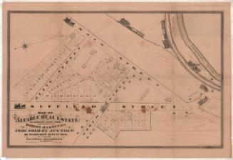
Map of Farmington River from Pine Meadow to the Iron Works
SurveyorSurveyed by
Hiram G. Loomis
(American, 1834 - 1911)
Date1859
MediumDrawing; black ink on paper, lined with linen
DimensionsPrimary Dimensions (image height x width): 26 1/4 x 46 1/4in. (66.7 x 117.5cm)
Sheet (height x width): 30 x 50 1/2in. (76.2 x 128.3cm)
Mount (height x width): 30 x 50 1/2in. (76.2 x 128.3cm)
ClassificationsGraphics
Credit LineConnecticut Museum of Culture and History collection
Object number1984.140.0
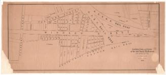
DescriptionMap of the Farmington River in New Hartford, Connecticut, as it flows south from a factory to the East River. The river is dammed above the Forge Canal, which is depicted with two bulkheads, a dam and gates. Property along the river is depicted, inscribed with the owner's name, geographic coordinates, dimensions in feet and chains, and area in acres, roods and rods. Some notable land features are shown, such as pine trees and stumps. The Albany Turnpike is shown running parallel to the river. At the bottom of the sheet is an elevation profile of rapids in the river, and at the top is a profile from the head of the breakwater to below the dam.
Label TextIn the mid-nineteenth century, the part of New Hartford east of Pine Meadow was known as the Furnace District or Puddletown, and was the site of an iron foundry, charcoal pits, tenement houses, and a tavern. The foundry was destroyed by fire in 1863 and never rebuilt. In the early twentieth century, the Albany Turnipike became Route 44 and by the end of the century, a condominium complex and a water treatment plant occupied the site of the former industrial area.
NotesCartographic Note: Scale: 1 inch equals 100 feetStatus
Not on view